You are here: Home > Network List > TA - USArray Transportable Network (new EarthScope stations) Stations List
> Station J26L Joseph Creek, AK, USA > Earthquake Result Viewer
J26L Joseph Creek, AK, USA - Earthquake Result Viewer
| Earthquake location: |
Santa Cruz Islands |
| Earthquake latitude/longitude: |
-12.6/167.0 |
| Earthquake time(UTC): |
2019/08/22 (234) 22:54:26 GMT |
| Earthquake Depth: |
213 km |
| Earthquake Magnitude: |
5.6 Mww |
| Earthquake Catalog/Contributor: |
NEIC PDE/us |
|
| Network: |
TA USArray Transportable Network (new EarthScope stations) |
| Station: |
J26L Joseph Creek, AK, USA |
| Lat/Lon: |
64.50 N/143.56 W |
| Elevation: |
1144 m |
|
| Distance: |
85.4 deg |
| Az: |
19.248 deg |
| Baz: |
228.034 deg |
| Ray Param: |
0.04427654 |
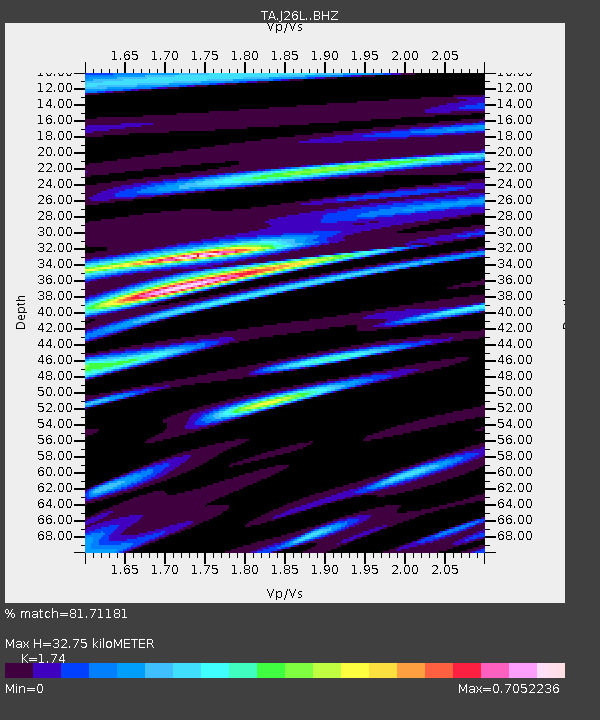
| Estimated Moho Depth: |
32.75 km |
| Estimated Crust Vp/Vs: |
1.74 |
| Assumed Crust Vp: |
6.566 km/s |
| Estimated Crust Vs: |
3.774 km/s |
| Estimated Crust Poisson's Ratio: |
0.25 |
|
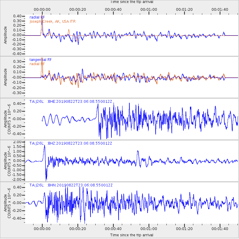
| Radial Match: |
81.71181 % |
| Radial Bump: |
400 |
| Transverse Match: |
67.12053 % |
| Transverse Bump: |
400 |
| SOD ConfigId: |
19053131 |
| Insert Time: |
2019-09-05 23:04:50.345 +0000 |
| GWidth: |
2.5 |
| Max Bumps: |
400 |
| Tol: |
0.001 |
|
Signal To Noise
| Channel | StoN | STA | LTA |
| TA:J26L: :BHZ:20190822T23:06:08.550012Z | 14.504633 | 8.6068377E-7 | 5.9338543E-8 |
| TA:J26L: :BHN:20190822T23:06:08.550012Z | 3.554422 | 1.9038667E-7 | 5.3563326E-8 |
| TA:J26L: :BHE:20190822T23:06:08.550012Z | 2.956642 | 2.1484217E-7 | 7.266426E-8 |
| Arrivals |
| Ps | 3.8 SECOND |
| PpPs | 13 SECOND |
| PsPs/PpSs | 17 SECOND |


