You are here: Home > Network List > US - United States National Seismic Network Stations List
> Station AMTX Amarillo, Texas, USA > Earthquake Result Viewer
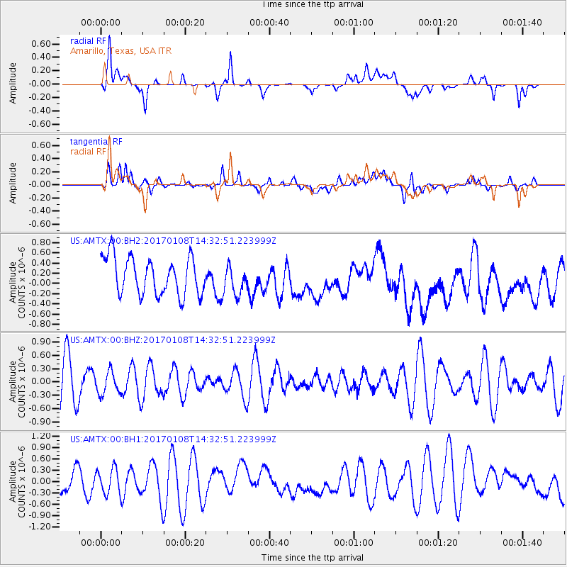
AMTX Amarillo, Texas, USA - Earthquake Result Viewer
*The percent match for this event was below the threshold and hence no stack was calculated.
| Earthquake location: |
Pacific-Antarctic Ridge |
| Earthquake latitude/longitude: |
-54.4/-135.8 |
| Earthquake time(UTC): |
2017/01/08 (008) 14:20:06 GMT |
| Earthquake Depth: |
10 km |
| Earthquake Magnitude: |
5.6 Mwc |
| Earthquake Catalog/Contributor: |
NEIC PDE/us |
|
| Network: |
US United States National Seismic Network |
| Station: |
AMTX Amarillo, Texas, USA |
| Lat/Lon: |
34.53 N/101.41 W |
| Elevation: |
1010 m |
|
| Distance: |
93.4 deg |
| Az: |
27.855 deg |
| Baz: |
199.346 deg |
| Ray Param: |
$rayparam |
*The percent match for this event was below the threshold and hence was not used in the summary stack. |
|
| Radial Match: |
58.783974 % |
| Radial Bump: |
400 |
| Transverse Match: |
40.92641 % |
| Transverse Bump: |
400 |
| SOD ConfigId: |
1943534 |
| Insert Time: |
2017-01-22 14:22:18.582 +0000 |
| GWidth: |
2.5 |
| Max Bumps: |
400 |
| Tol: |
0.001 |
|
Signal To Noise
| Channel | StoN | STA | LTA |
| US:AMTX:00:BHZ:20170108T14:32:51.223999Z | 0.37451538 | 2.553333E-7 | 6.8176985E-7 |
| US:AMTX:00:BH1:20170108T14:32:51.223999Z | 0.9067074 | 3.3892994E-7 | 3.7380298E-7 |
| US:AMTX:00:BH2:20170108T14:32:51.223999Z | 1.0104991 | 3.6942203E-7 | 3.655837E-7 |
| Arrivals |
| Ps | |
| PpPs | |
| PsPs/PpSs | |


