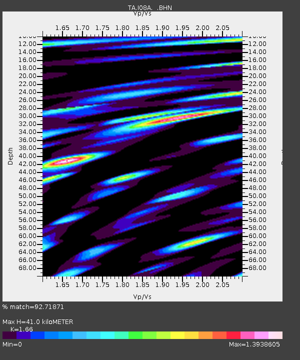
I08A Drewsey, OR, USA - Earthquake Result Viewer
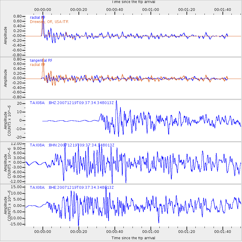
Earthquake location: Andreanof Islands, Aleutian Is.
Earthquake latitude/longitude: 51.4/-179.5
Earthquake time(UTC): 2007/12/19 (353) 09:30:27 GMT
Earthquake Depth: 29 km
Earthquake Magnitude: 6.4 MB, 7.1 MS, 7.1 MW, 7.0 MW
Earthquake Catalog/Contributor: WHDF/NEIC
Network: TA USArray Transportable Network (new EarthScope stations)
Station: I08A Drewsey, OR, USA
Lat/Lon: 43.91 N/118.57 W
Elevation: 1189 m
Distance: 40.7 deg
Az: 75.798 deg
Baz: 302.761 deg
Ray Param: 0.074208535
Estimated Moho Depth: 41.0 km
Estimated Crust Vp/Vs: 1.66
Assumed Crust Vp: 6.279 km/s
Estimated Crust Vs: 3.782 km/s
Estimated Crust Poisson's Ratio: 0.22
Radial Match: 92.71871 %
Radial Bump: 400
Transverse Match: 76.321205 %
Transverse Bump: 400
SOD ConfigId: 2564
Insert Time: 2010-03-07 03:34:36.202 +0000
GWidth: 2.5
Max Bumps: 400
Tol: 0.001

Signal To Noise

ChannelStoNSTALTA
TA:I08A: :BHN:20071219T09:37:34.348013Z2.59245061.3354548E-65.151322E-7
TA:I08A: :BHE:20071219T09:37:34.348013Z5.2933961.816509E-63.4316514E-7
TA:I08A: :BHZ:20071219T09:37:34.348013Z9.7402013.6543652E-63.7518373E-7
Arrivals
Ps4.6 SECOND
PpPs16 SECOND
PsPs/PpSs21 SECOND