You are here: Home > Network List > TA - USArray Transportable Network (new EarthScope stations) Stations List
> Station I08A Drewsey, OR, USA > Earthquake Result Viewer
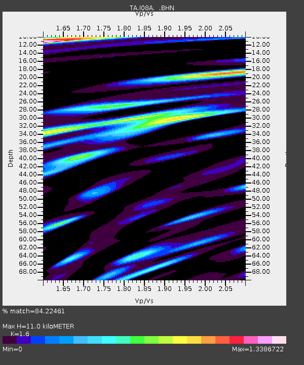
I08A Drewsey, OR, USA - Earthquake Result Viewer
| Earthquake location: |
Peru-Ecuador Border Region |
| Earthquake latitude/longitude: |
-2.3/-77.8 |
| Earthquake time(UTC): |
2007/11/16 (320) 03:13:00 GMT |
| Earthquake Depth: |
123 km |
| Earthquake Magnitude: |
6.3 MB, 6.8 MW, 6.7 MW |
| Earthquake Catalog/Contributor: |
WHDF/NEIC |
|
| Network: |
TA USArray Transportable Network (new EarthScope stations) |
| Station: |
I08A Drewsey, OR, USA |
| Lat/Lon: |
43.91 N/118.57 W |
| Elevation: |
1189 m |
|
| Distance: |
58.7 deg |
| Az: |
326.5 deg |
| Baz: |
130.265 deg |
| Ray Param: |
0.06230304 |
| Estimated Moho Depth: |
11.0 km |
| Estimated Crust Vp/Vs: |
1.60 |
| Assumed Crust Vp: |
6.279 km/s |
| Estimated Crust Vs: |
3.924 km/s |
| Estimated Crust Poisson's Ratio: |
0.18 |
|
| Radial Match: |
84.22461 % |
| Radial Bump: |
400 |
| Transverse Match: |
67.89273 % |
| Transverse Bump: |
400 |
| SOD ConfigId: |
2564 |
| Insert Time: |
2010-03-07 03:34:39.568 +0000 |
| GWidth: |
2.5 |
| Max Bumps: |
400 |
| Tol: |
0.001 |
|

Signal To Noise
| Channel | StoN | STA | LTA |
| TA:I08A: :BHN:20071116T03:22:14.150029Z | 3.0539315 | 7.628694E-7 | 2.4979911E-7 |
| TA:I08A: :BHE:20071116T03:22:14.150029Z | 1.8766255 | 6.6181354E-7 | 3.5266146E-7 |
| TA:I08A: :BHZ:20071116T03:22:14.150029Z | 3.4098222 | 1.179387E-6 | 3.4587936E-7 |
| Arrivals |
| Ps | 1.1 SECOND |
| PpPs | 4.3 SECOND |
| PsPs/PpSs | 5.4 SECOND |


