You are here: Home > Network List > TA - USArray Transportable Network (new EarthScope stations) Stations List
> Station I08A Drewsey, OR, USA > Earthquake Result Viewer
I08A Drewsey, OR, USA - Earthquake Result Viewer
| Earthquake location: |
Near Coast Of Peru |
| Earthquake latitude/longitude: |
-14.2/-75.9 |
| Earthquake time(UTC): |
2007/08/16 (228) 00:19:13 GMT |
| Earthquake Depth: |
35 km |
| Earthquake Magnitude: |
5.8 MB |
| Earthquake Catalog/Contributor: |
WHDF/NEIC |
|
| Network: |
TA USArray Transportable Network (new EarthScope stations) |
| Station: |
I08A Drewsey, OR, USA |
| Lat/Lon: |
43.91 N/118.57 W |
| Elevation: |
1189 m |
|
| Distance: |
69.7 deg |
| Az: |
328.543 deg |
| Baz: |
135.558 deg |
| Ray Param: |
0.055417128 |
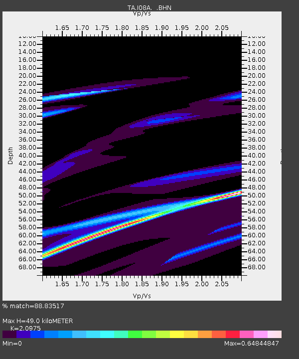
| Estimated Moho Depth: |
49.0 km |
| Estimated Crust Vp/Vs: |
2.10 |
| Assumed Crust Vp: |
6.279 km/s |
| Estimated Crust Vs: |
2.993 km/s |
| Estimated Crust Poisson's Ratio: |
0.35 |
|
| Radial Match: |
88.83517 % |
| Radial Bump: |
235 |
| Transverse Match: |
58.020206 % |
| Transverse Bump: |
342 |
| SOD ConfigId: |
2564 |
| Insert Time: |
2010-03-07 03:34:51.753 +0000 |
| GWidth: |
2.5 |
| Max Bumps: |
400 |
| Tol: |
0.001 |
|

Signal To Noise
| Channel | StoN | STA | LTA |
| TA:I08A: :BHN:20070816T00:29:49.225022Z | 1.7573116 | 8.894184E-5 | 5.0612445E-5 |
| TA:I08A: :BHE:20070816T00:29:49.225022Z | 1.5903153 | 3.3992026E-5 | 2.1374393E-5 |
| TA:I08A: :BHZ:20070816T00:29:49.225022Z | 0.9105598 | 5.4575037E-5 | 5.99357E-5 |
| Arrivals |
| Ps | 8.8 SECOND |
| PpPs | 23 SECOND |
| PsPs/PpSs | 32 SECOND |


