You are here: Home > Network List > TA - USArray Transportable Network (new EarthScope stations) Stations List
> Station I08A Drewsey, OR, USA > Earthquake Result Viewer
I08A Drewsey, OR, USA - Earthquake Result Viewer
| Earthquake location: |
Sea Of Japan |
| Earthquake latitude/longitude: |
36.8/134.9 |
| Earthquake time(UTC): |
2007/07/16 (197) 14:17:37 GMT |
| Earthquake Depth: |
350 km |
| Earthquake Magnitude: |
6.2 MB, 6.8 MW, 6.8 MW |
| Earthquake Catalog/Contributor: |
WHDF/NEIC |
|
| Network: |
TA USArray Transportable Network (new EarthScope stations) |
| Station: |
I08A Drewsey, OR, USA |
| Lat/Lon: |
43.91 N/118.57 W |
| Elevation: |
1189 m |
|
| Distance: |
75.7 deg |
| Az: |
45.627 deg |
| Baz: |
307.463 deg |
| Ray Param: |
0.0504861 |
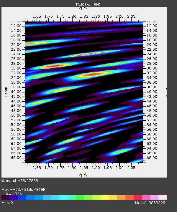
| Estimated Moho Depth: |
23.75 km |
| Estimated Crust Vp/Vs: |
1.88 |
| Assumed Crust Vp: |
6.279 km/s |
| Estimated Crust Vs: |
3.349 km/s |
| Estimated Crust Poisson's Ratio: |
0.30 |
|
| Radial Match: |
88.47888 % |
| Radial Bump: |
400 |
| Transverse Match: |
77.83073 % |
| Transverse Bump: |
400 |
| SOD ConfigId: |
2564 |
| Insert Time: |
2010-03-07 03:35:03.577 +0000 |
| GWidth: |
2.5 |
| Max Bumps: |
400 |
| Tol: |
0.001 |
|

Signal To Noise
| Channel | StoN | STA | LTA |
| TA:I08A: :BHN:20070716T14:28:14.074009Z | 16.284225 | 8.0663125E-7 | 4.9534517E-8 |
| TA:I08A: :BHE:20070716T14:28:14.074009Z | 23.262133 | 1.3135337E-6 | 5.646661E-8 |
| TA:I08A: :BHZ:20070716T14:28:14.074009Z | 52.31254 | 3.6466797E-6 | 6.970948E-8 |
| Arrivals |
| Ps | 3.4 SECOND |
| PpPs | 11 SECOND |
| PsPs/PpSs | 14 SECOND |


