You are here: Home > Network List > TA - USArray Transportable Network (new EarthScope stations) Stations List
> Station I08A Drewsey, OR, USA > Earthquake Result Viewer
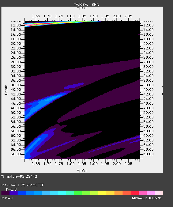
I08A Drewsey, OR, USA - Earthquake Result Viewer
| Earthquake location: |
Solomon Islands |
| Earthquake latitude/longitude: |
-7.3/155.7 |
| Earthquake time(UTC): |
2007/04/01 (091) 21:11:33 GMT |
| Earthquake Depth: |
10 km |
| Earthquake Magnitude: |
6.3 MB |
| Earthquake Catalog/Contributor: |
WHDF/NEIC |
|
| Network: |
TA USArray Transportable Network (new EarthScope stations) |
| Station: |
I08A Drewsey, OR, USA |
| Lat/Lon: |
43.91 N/118.57 W |
| Elevation: |
1189 m |
|
| Distance: |
91.9 deg |
| Az: |
46.146 deg |
| Baz: |
261.784 deg |
| Ray Param: |
0.041537378 |
| Estimated Moho Depth: |
11.75 km |
| Estimated Crust Vp/Vs: |
1.60 |
| Assumed Crust Vp: |
6.279 km/s |
| Estimated Crust Vs: |
3.924 km/s |
| Estimated Crust Poisson's Ratio: |
0.18 |
|
| Radial Match: |
92.23442 % |
| Radial Bump: |
400 |
| Transverse Match: |
42.085766 % |
| Transverse Bump: |
400 |
| SOD ConfigId: |
2564 |
| Insert Time: |
2010-03-07 03:35:17.535 +0000 |
| GWidth: |
2.5 |
| Max Bumps: |
400 |
| Tol: |
0.001 |
|

Signal To Noise
| Channel | StoN | STA | LTA |
| TA:I08A: :BHN:20070401T21:24:10.025Z | 0.7905654 | 2.679567E-5 | 3.3894314E-5 |
| TA:I08A: :BHE:20070401T21:24:10.025Z | 1.2198067 | 2.711652E-5 | 2.2230179E-5 |
| TA:I08A: :BHZ:20070401T21:24:10.025Z | 2.9298635 | 6.4043255E-5 | 2.1858787E-5 |
| Arrivals |
| Ps | 1.1 SECOND |
| PpPs | 4.8 SECOND |
| PsPs/PpSs | 5.9 SECOND |


