You are here: Home > Network List > TA - USArray Transportable Network (new EarthScope stations) Stations List
> Station I08A Drewsey, OR, USA > Earthquake Result Viewer
I08A Drewsey, OR, USA - Earthquake Result Viewer
| Earthquake location: |
Solomon Islands |
| Earthquake latitude/longitude: |
-8.5/157.0 |
| Earthquake time(UTC): |
2007/04/01 (091) 20:39:56 GMT |
| Earthquake Depth: |
10 km |
| Earthquake Magnitude: |
6.8 MB, 7.9 MS, 8.1 MW, 7.7 ME |
| Earthquake Catalog/Contributor: |
WHDF/NEIC |
|
| Network: |
TA USArray Transportable Network (new EarthScope stations) |
| Station: |
I08A Drewsey, OR, USA |
| Lat/Lon: |
43.91 N/118.57 W |
| Elevation: |
1189 m |
|
| Distance: |
91.8 deg |
| Az: |
46.024 deg |
| Baz: |
260.062 deg |
| Ray Param: |
0.041557796 |
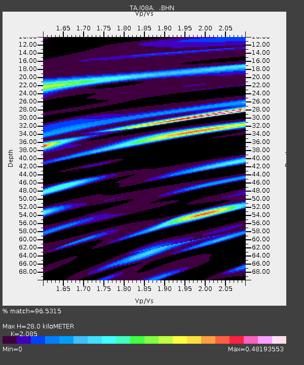
| Estimated Moho Depth: |
28.0 km |
| Estimated Crust Vp/Vs: |
2.09 |
| Assumed Crust Vp: |
6.279 km/s |
| Estimated Crust Vs: |
3.011 km/s |
| Estimated Crust Poisson's Ratio: |
0.35 |
|
| Radial Match: |
96.5315 % |
| Radial Bump: |
400 |
| Transverse Match: |
77.68273 % |
| Transverse Bump: |
400 |
| SOD ConfigId: |
2564 |
| Insert Time: |
2010-03-07 03:35:19.504 +0000 |
| GWidth: |
2.5 |
| Max Bumps: |
400 |
| Tol: |
0.001 |
|
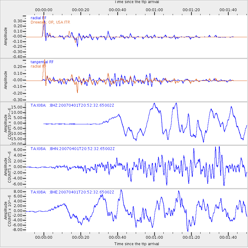
Signal To Noise
| Channel | StoN | STA | LTA |
| TA:I08A: :BHN:20070401T20:52:32.65002Z | 0.93176204 | 1.2647746E-7 | 1.3574008E-7 |
| TA:I08A: :BHE:20070401T20:52:32.65002Z | 3.8562953 | 4.5953078E-7 | 1.1916379E-7 |
| TA:I08A: :BHZ:20070401T20:52:32.65002Z | 14.489612 | 1.4098018E-6 | 9.729742E-8 |
| Arrivals |
| Ps | 4.9 SECOND |
| PpPs | 14 SECOND |
| PsPs/PpSs | 18 SECOND |


