You are here: Home > Network List > TA - USArray Transportable Network (new EarthScope stations) Stations List
> Station I08A Drewsey, OR, USA > Earthquake Result Viewer
I08A Drewsey, OR, USA - Earthquake Result Viewer
| Earthquake location: |
Kuril Islands |
| Earthquake latitude/longitude: |
46.9/153.7 |
| Earthquake time(UTC): |
2006/11/15 (319) 11:33:23 GMT |
| Earthquake Depth: |
10 km |
| Earthquake Magnitude: |
5.5 MB |
| Earthquake Catalog/Contributor: |
WHDF/NEIC |
|
| Network: |
TA USArray Transportable Network (new EarthScope stations) |
| Station: |
I08A Drewsey, OR, USA |
| Lat/Lon: |
43.91 N/118.57 W |
| Elevation: |
1189 m |
|
| Distance: |
58.5 deg |
| Az: |
57.893 deg |
| Baz: |
306.465 deg |
| Ray Param: |
0.06280971 |
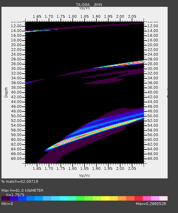
| Estimated Moho Depth: |
61.0 km |
| Estimated Crust Vp/Vs: |
1.76 |
| Assumed Crust Vp: |
6.279 km/s |
| Estimated Crust Vs: |
3.572 km/s |
| Estimated Crust Poisson's Ratio: |
0.26 |
|
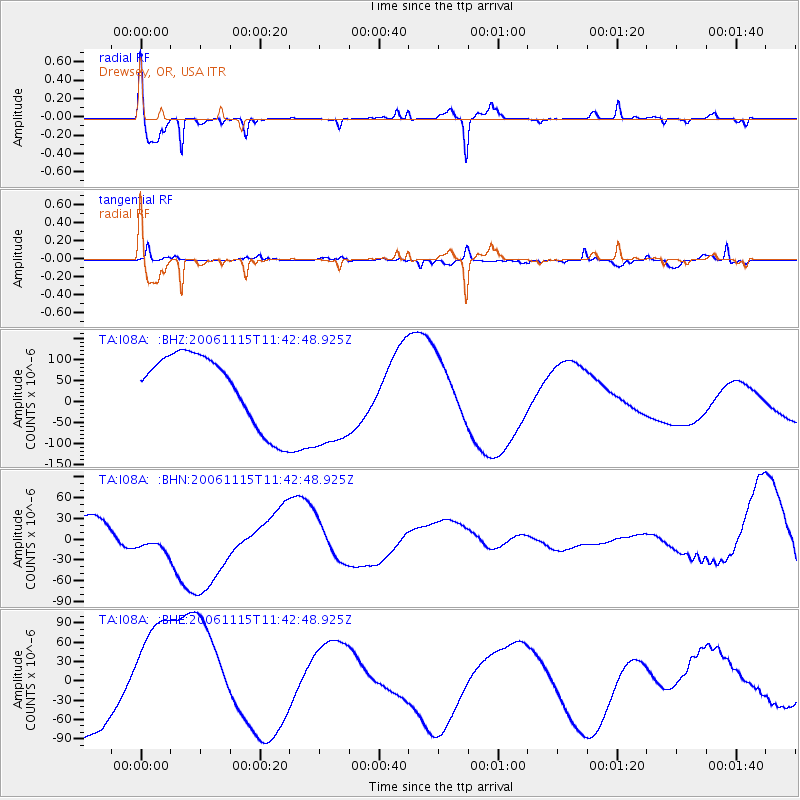
| Radial Match: |
82.09719 % |
| Radial Bump: |
374 |
| Transverse Match: |
66.99542 % |
| Transverse Bump: |
361 |
| SOD ConfigId: |
2564 |
| Insert Time: |
2010-03-07 03:35:29.934 +0000 |
| GWidth: |
2.5 |
| Max Bumps: |
400 |
| Tol: |
0.001 |
|
Signal To Noise
| Channel | StoN | STA | LTA |
| TA:I08A: :BHN:20061115T11:42:48.925Z | 0.6486788 | 2.2868173E-5 | 3.5253463E-5 |
| TA:I08A: :BHE:20061115T11:42:48.925Z | 1.1554883 | 1.0025851E-4 | 8.676723E-5 |
| TA:I08A: :BHZ:20061115T11:42:48.925Z | 1.5416148 | 1.307098E-4 | 8.4787585E-5 |
| Arrivals |
| Ps | 7.7 SECOND |
| PpPs | 26 SECOND |
| PsPs/PpSs | 33 SECOND |


