You are here: Home > Network List > TA - USArray Transportable Network (new EarthScope stations) Stations List
> Station I08A Drewsey, OR, USA > Earthquake Result Viewer
I08A Drewsey, OR, USA - Earthquake Result Viewer
| Earthquake location: |
Southern Peru |
| Earthquake latitude/longitude: |
-15.6/-73.2 |
| Earthquake time(UTC): |
2006/09/30 (273) 16:26:56 GMT |
| Earthquake Depth: |
107 km |
| Earthquake Magnitude: |
5.6 MB, 6.0 MW, 5.9 MW |
| Earthquake Catalog/Contributor: |
WHDF/NEIC |
|
| Network: |
TA USArray Transportable Network (new EarthScope stations) |
| Station: |
I08A Drewsey, OR, USA |
| Lat/Lon: |
43.91 N/118.57 W |
| Elevation: |
1189 m |
|
| Distance: |
72.3 deg |
| Az: |
327.293 deg |
| Baz: |
133.906 deg |
| Ray Param: |
0.053506225 |
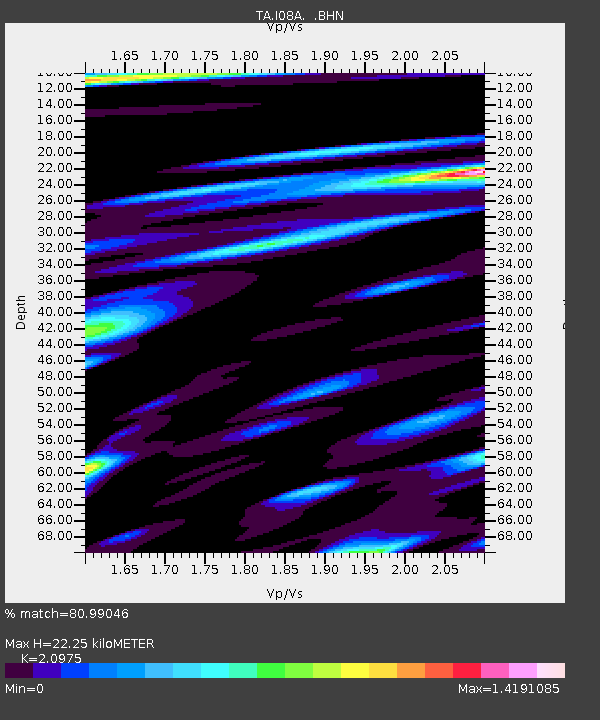
| Estimated Moho Depth: |
22.25 km |
| Estimated Crust Vp/Vs: |
2.10 |
| Assumed Crust Vp: |
6.279 km/s |
| Estimated Crust Vs: |
2.993 km/s |
| Estimated Crust Poisson's Ratio: |
0.35 |
|
| Radial Match: |
80.99046 % |
| Radial Bump: |
400 |
| Transverse Match: |
56.280697 % |
| Transverse Bump: |
400 |
| SOD ConfigId: |
2564 |
| Insert Time: |
2010-03-07 03:35:35.934 +0000 |
| GWidth: |
2.5 |
| Max Bumps: |
400 |
| Tol: |
0.001 |
|
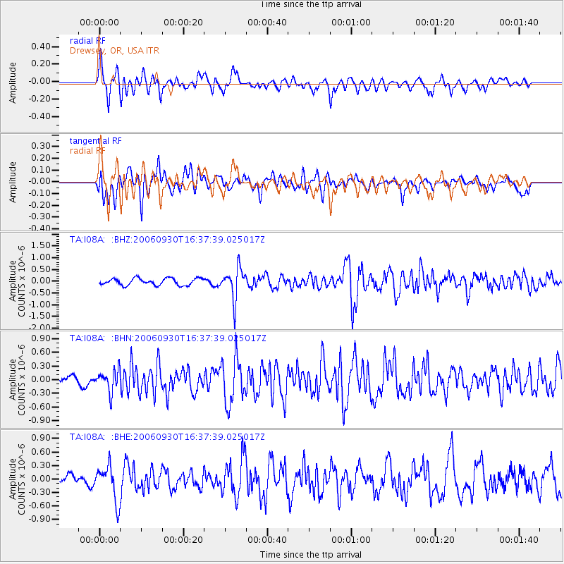
Signal To Noise
| Channel | StoN | STA | LTA |
| TA:I08A: :BHN:20060930T16:37:39.025017Z | 2.2085836 | 2.445286E-7 | 1.1071737E-7 |
| TA:I08A: :BHE:20060930T16:37:39.025017Z | 3.4103463 | 4.0761603E-7 | 1.1952335E-7 |
| TA:I08A: :BHZ:20060930T16:37:39.025017Z | 4.852574 | 7.0085446E-7 | 1.4442942E-7 |
| Arrivals |
| Ps | 4.0 SECOND |
| PpPs | 11 SECOND |
| PsPs/PpSs | 15 SECOND |


