You are here: Home > Network List > GS - US Geological Survey Networks Stations List
> Station DEC09 Decatur Surface Seismic Site, Decatur, IL, USA > Earthquake Result Viewer
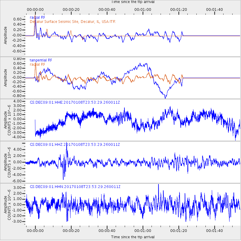
DEC09 Decatur Surface Seismic Site, Decatur, IL, USA - Earthquake Result Viewer
*The percent match for this event was below the threshold and hence no stack was calculated.
| Earthquake location: |
Queen Elizabeth Islands, Canada |
| Earthquake latitude/longitude: |
74.3/-92.3 |
| Earthquake time(UTC): |
2017/01/08 (008) 23:47:12 GMT |
| Earthquake Depth: |
19 km |
| Earthquake Magnitude: |
5.8 Mwp |
| Earthquake Catalog/Contributor: |
NEIC PDE/us |
|
| Network: |
GS US Geological Survey Networks |
| Station: |
DEC09 Decatur Surface Seismic Site, Decatur, IL, USA |
| Lat/Lon: |
39.87 N/88.92 W |
| Elevation: |
207 m |
|
| Distance: |
34.6 deg |
| Az: |
175.412 deg |
| Baz: |
358.38 deg |
| Ray Param: |
$rayparam |
*The percent match for this event was below the threshold and hence was not used in the summary stack. |
|
| Radial Match: |
66.316414 % |
| Radial Bump: |
400 |
| Transverse Match: |
49.372894 % |
| Transverse Bump: |
400 |
| SOD ConfigId: |
1943534 |
| Insert Time: |
2017-01-22 23:49:58.804 +0000 |
| GWidth: |
2.5 |
| Max Bumps: |
400 |
| Tol: |
0.001 |
|
Signal To Noise
| Channel | StoN | STA | LTA |
| GS:DEC09:01:HHZ:20170108T23:53:29.260011Z | 1.4574367 | 6.5593684E-7 | 4.50062E-7 |
| GS:DEC09:01:HHN:20170108T23:53:29.260011Z | 1.5132354 | 9.2727294E-7 | 6.1277507E-7 |
| GS:DEC09:01:HHE:20170108T23:53:29.260011Z | 1.6435986 | 2.4438082E-6 | 1.4868643E-6 |
| Arrivals |
| Ps | |
| PpPs | |
| PsPs/PpSs | |


