You are here: Home > Network List > TA - USArray Transportable Network (new EarthScope stations) Stations List
> Station I08A Drewsey, OR, USA > Earthquake Result Viewer
I08A Drewsey, OR, USA - Earthquake Result Viewer

| Earthquake location: |
Gulf Of Mexico |
| Earthquake latitude/longitude: |
26.3/-86.6 |
| Earthquake time(UTC): |
2006/09/10 (253) 14:56:08 GMT |
| Earthquake Depth: |
14 km |
| Earthquake Magnitude: |
5.9 MB, 5.5 MS, 5.8 MW, 5.8 MW |
| Earthquake Catalog/Contributor: |
WHDF/NEIC |
|
| Network: |
TA USArray Transportable Network (new EarthScope stations) |
| Station: |
I08A Drewsey, OR, USA |
| Lat/Lon: |
43.91 N/118.57 W |
| Elevation: |
1189 m |
|
| Distance: |
31.2 deg |
| Az: |
312.443 deg |
| Baz: |
113.595 deg |
| Ray Param: |
0.07911923 |
| Estimated Moho Depth: |
11.25 km |
| Estimated Crust Vp/Vs: |
1.60 |
| Assumed Crust Vp: |
6.279 km/s |
| Estimated Crust Vs: |
3.924 km/s |
| Estimated Crust Poisson's Ratio: |
0.18 |
|
| Radial Match: |
87.981445 % |
| Radial Bump: |
400 |
| Transverse Match: |
90.34576 % |
| Transverse Bump: |
400 |
| SOD ConfigId: |
2665 |
| Insert Time: |
2010-03-07 03:35:54.468 +0000 |
| GWidth: |
2.5 |
| Max Bumps: |
400 |
| Tol: |
0.001 |
|
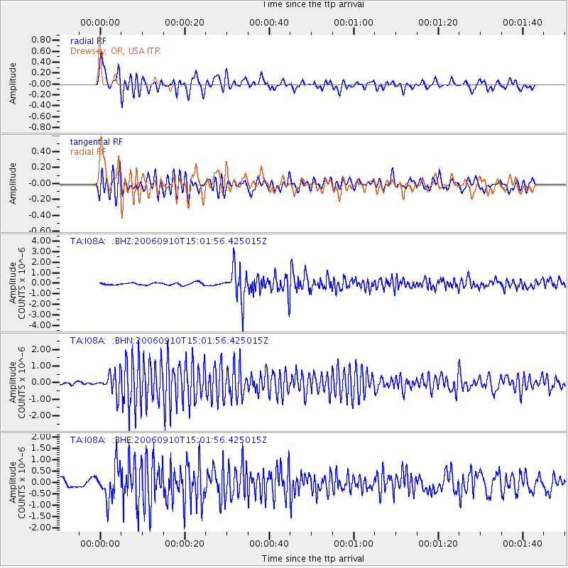
Signal To Noise
| Channel | StoN | STA | LTA |
| TA:I08A: :BHN:20060910T15:01:56.425015Z | 7.501897 | 6.096127E-7 | 8.126114E-8 |
| TA:I08A: :BHE:20060910T15:01:56.425015Z | 5.0452967 | 7.297317E-7 | 1.4463603E-7 |
| TA:I08A: :BHZ:20060910T15:01:56.425015Z | 14.096951 | 1.5543875E-6 | 1.1026409E-7 |
| Arrivals |
| Ps | 1.2 SECOND |
| PpPs | 4.3 SECOND |
| PsPs/PpSs | 5.5 SECOND |


