You are here: Home > Network List > TA - USArray Transportable Network (new EarthScope stations) Stations List
> Station I08A Drewsey, OR, USA > Earthquake Result Viewer
I08A Drewsey, OR, USA - Earthquake Result Viewer
| Earthquake location: |
Near Coast Of Northern Chile |
| Earthquake latitude/longitude: |
-20.2/-70.0 |
| Earthquake time(UTC): |
2008/02/04 (035) 17:01:30 GMT |
| Earthquake Depth: |
44 km |
| Earthquake Magnitude: |
6.0 MB, 6.2 MS, 6.3 MW, 6.3 MW |
| Earthquake Catalog/Contributor: |
WHDF/NEIC |
|
| Network: |
TA USArray Transportable Network (new EarthScope stations) |
| Station: |
I08A Drewsey, OR, USA |
| Lat/Lon: |
43.91 N/118.57 W |
| Elevation: |
1189 m |
|
| Distance: |
77.7 deg |
| Az: |
326.34 deg |
| Baz: |
133.909 deg |
| Ray Param: |
0.05006013 |
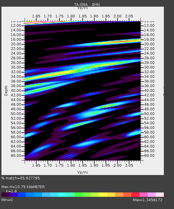
| Estimated Moho Depth: |
10.75 km |
| Estimated Crust Vp/Vs: |
1.60 |
| Assumed Crust Vp: |
6.279 km/s |
| Estimated Crust Vs: |
3.924 km/s |
| Estimated Crust Poisson's Ratio: |
0.18 |
|
| Radial Match: |
85.927795 % |
| Radial Bump: |
400 |
| Transverse Match: |
62.168392 % |
| Transverse Bump: |
400 |
| SOD ConfigId: |
2564 |
| Insert Time: |
2010-03-07 03:36:12.757 +0000 |
| GWidth: |
2.5 |
| Max Bumps: |
400 |
| Tol: |
0.001 |
|

Signal To Noise
| Channel | StoN | STA | LTA |
| TA:I08A: :BHN:20080204T17:12:52.199004Z | 2.5916462 | 1.0009774E-6 | 3.8623224E-7 |
| TA:I08A: :BHE:20080204T17:12:52.199004Z | 1.9935422 | 1.0200957E-6 | 5.117001E-7 |
| TA:I08A: :BHZ:20080204T17:12:52.199004Z | 12.842868 | 2.918102E-6 | 2.2721575E-7 |
| Arrivals |
| Ps | 1.1 SECOND |
| PpPs | 4.3 SECOND |
| PsPs/PpSs | 5.4 SECOND |


