You are here: Home > Network List > TA - USArray Transportable Network (new EarthScope stations) Stations List
> Station P05C Yuba Gap, Truckee, CA, USA > Earthquake Result Viewer
P05C Yuba Gap, Truckee, CA, USA - Earthquake Result Viewer
| Earthquake location: |
Panama-Costa Rica Border Region |
| Earthquake latitude/longitude: |
8.4/-82.9 |
| Earthquake time(UTC): |
2005/06/30 (181) 21:26:36 GMT |
| Earthquake Depth: |
38 km |
| Earthquake Magnitude: |
5.3 MB, 5.6 MS, 6.0 MW, 5.8 MW |
| Earthquake Catalog/Contributor: |
WHDF/NEIC |
|
| Network: |
TA USArray Transportable Network (new EarthScope stations) |
| Station: |
P05C Yuba Gap, Truckee, CA, USA |
| Lat/Lon: |
39.30 N/120.61 W |
| Elevation: |
1756 m |
|
| Distance: |
45.6 deg |
| Az: |
318.386 deg |
| Baz: |
122.138 deg |
| Ray Param: |
0.07105716 |
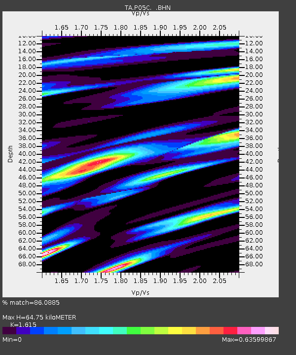
| Estimated Moho Depth: |
64.75 km |
| Estimated Crust Vp/Vs: |
1.62 |
| Assumed Crust Vp: |
6.597 km/s |
| Estimated Crust Vs: |
4.085 km/s |
| Estimated Crust Poisson's Ratio: |
0.19 |
|
| Radial Match: |
86.0885 % |
| Radial Bump: |
400 |
| Transverse Match: |
62.69491 % |
| Transverse Bump: |
400 |
| SOD ConfigId: |
142937 |
| Insert Time: |
2010-03-07 03:36:34.807 +0000 |
| GWidth: |
2.5 |
| Max Bumps: |
400 |
| Tol: |
0.001 |
|

Signal To Noise
| Channel | StoN | STA | LTA |
| TA:P05C: :BHN:20050630T21:34:22.350006Z | 2.0182505 | 1.6561305E-7 | 8.205773E-8 |
| TA:P05C: :BHE:20050630T21:34:22.350006Z | 4.243843 | 2.9763848E-7 | 7.013419E-8 |
| TA:P05C: :BHZ:20050630T21:34:22.350006Z | 11.947768 | 6.015916E-7 | 5.0351794E-8 |
| Arrivals |
| Ps | 6.5 SECOND |
| PpPs | 24 SECOND |
| PsPs/PpSs | 30 SECOND |


