You are here: Home > Network List > TA - USArray Transportable Network (new EarthScope stations) Stations List
> Station P05C Yuba Gap, Truckee, CA, USA > Earthquake Result Viewer
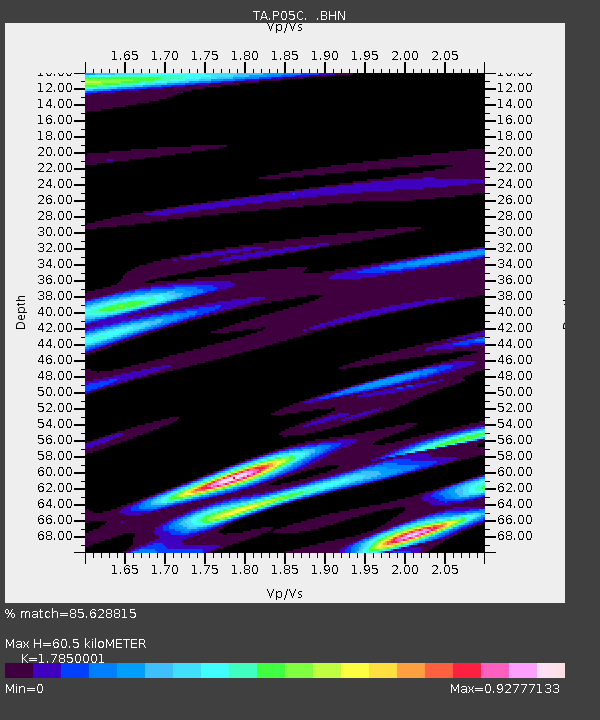
P05C Yuba Gap, Truckee, CA, USA - Earthquake Result Viewer
| Earthquake location: |
Easter Island Region |
| Earthquake latitude/longitude: |
-23.8/-111.7 |
| Earthquake time(UTC): |
2005/07/11 (192) 12:01:35 GMT |
| Earthquake Depth: |
10 km |
| Earthquake Magnitude: |
6.0 MB, 5.4 MS, 5.8 MW, 5.8 MW |
| Earthquake Catalog/Contributor: |
WHDF/NEIC |
|
| Network: |
TA USArray Transportable Network (new EarthScope stations) |
| Station: |
P05C Yuba Gap, Truckee, CA, USA |
| Lat/Lon: |
39.30 N/120.61 W |
| Elevation: |
1756 m |
|
| Distance: |
63.3 deg |
| Az: |
352.257 deg |
| Baz: |
170.85 deg |
| Ray Param: |
0.05963807 |
| Estimated Moho Depth: |
60.5 km |
| Estimated Crust Vp/Vs: |
1.79 |
| Assumed Crust Vp: |
6.597 km/s |
| Estimated Crust Vs: |
3.696 km/s |
| Estimated Crust Poisson's Ratio: |
0.27 |
|
| Radial Match: |
85.628815 % |
| Radial Bump: |
400 |
| Transverse Match: |
84.13832 % |
| Transverse Bump: |
400 |
| SOD ConfigId: |
2475 |
| Insert Time: |
2010-03-07 03:36:44.996 +0000 |
| GWidth: |
2.5 |
| Max Bumps: |
400 |
| Tol: |
0.001 |
|

Signal To Noise
| Channel | StoN | STA | LTA |
| TA:P05C: :BHN:20050711T12:11:33.274006Z | 2.499085 | 1.3716588E-7 | 5.4886442E-8 |
| TA:P05C: :BHE:20050711T12:11:33.274006Z | 0.97565675 | 5.0289096E-8 | 5.154384E-8 |
| TA:P05C: :BHZ:20050711T12:11:33.274006Z | 6.6105857 | 3.8268797E-7 | 5.789018E-8 |
| Arrivals |
| Ps | 7.5 SECOND |
| PpPs | 24 SECOND |
| PsPs/PpSs | 32 SECOND |


