You are here: Home > Network List > TA - USArray Transportable Network (new EarthScope stations) Stations List
> Station P05C Yuba Gap, Truckee, CA, USA > Earthquake Result Viewer
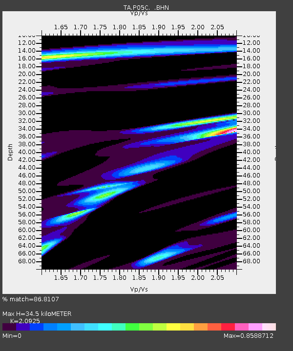
P05C Yuba Gap, Truckee, CA, USA - Earthquake Result Viewer
| Earthquake location: |
Fiji Islands Region |
| Earthquake latitude/longitude: |
-14.4/-177.3 |
| Earthquake time(UTC): |
2005/08/07 (219) 11:35:26 GMT |
| Earthquake Depth: |
10 km |
| Earthquake Magnitude: |
5.7 MB, 5.9 MS, 6.0 MW, 6.0 MW |
| Earthquake Catalog/Contributor: |
WHDF/NEIC |
|
| Network: |
TA USArray Transportable Network (new EarthScope stations) |
| Station: |
P05C Yuba Gap, Truckee, CA, USA |
| Lat/Lon: |
39.30 N/120.61 W |
| Elevation: |
1756 m |
|
| Distance: |
75.1 deg |
| Az: |
42.13 deg |
| Baz: |
236.885 deg |
| Ray Param: |
0.051864758 |
| Estimated Moho Depth: |
34.5 km |
| Estimated Crust Vp/Vs: |
2.09 |
| Assumed Crust Vp: |
6.597 km/s |
| Estimated Crust Vs: |
3.153 km/s |
| Estimated Crust Poisson's Ratio: |
0.35 |
|
| Radial Match: |
86.8107 % |
| Radial Bump: |
385 |
| Transverse Match: |
83.51689 % |
| Transverse Bump: |
400 |
| SOD ConfigId: |
2475 |
| Insert Time: |
2010-03-07 03:36:53.136 +0000 |
| GWidth: |
2.5 |
| Max Bumps: |
400 |
| Tol: |
0.001 |
|

Signal To Noise
| Channel | StoN | STA | LTA |
| TA:P05C: :BHN:20050807T11:46:37.124009Z | 1.3852861 | 9.201125E-8 | 6.64204E-8 |
| TA:P05C: :BHE:20050807T11:46:37.124009Z | 2.4173286 | 1.4119273E-7 | 5.8408578E-8 |
| TA:P05C: :BHZ:20050807T11:46:37.124009Z | 2.810739 | 2.5916708E-7 | 9.220602E-8 |
| Arrivals |
| Ps | 5.9 SECOND |
| PpPs | 16 SECOND |
| PsPs/PpSs | 22 SECOND |


