You are here: Home > Network List > TA - USArray Transportable Network (new EarthScope stations) Stations List
> Station P05C Yuba Gap, Truckee, CA, USA > Earthquake Result Viewer
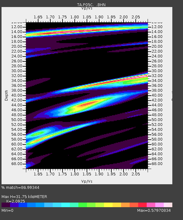
P05C Yuba Gap, Truckee, CA, USA - Earthquake Result Viewer
| Earthquake location: |
Vanuatu Islands Region |
| Earthquake latitude/longitude: |
-21.1/173.9 |
| Earthquake time(UTC): |
2005/08/09 (221) 14:12:21 GMT |
| Earthquake Depth: |
35 km |
| Earthquake Magnitude: |
5.3 MB, 5.9 MS, 6.1 MW, 6.0 MW |
| Earthquake Catalog/Contributor: |
WHDF/NEIC |
|
| Network: |
TA USArray Transportable Network (new EarthScope stations) |
| Station: |
P05C Yuba Gap, Truckee, CA, USA |
| Lat/Lon: |
39.30 N/120.61 W |
| Elevation: |
1756 m |
|
| Distance: |
85.7 deg |
| Az: |
45.08 deg |
| Baz: |
238.451 deg |
| Ray Param: |
0.04450922 |
| Estimated Moho Depth: |
31.75 km |
| Estimated Crust Vp/Vs: |
2.09 |
| Assumed Crust Vp: |
6.597 km/s |
| Estimated Crust Vs: |
3.153 km/s |
| Estimated Crust Poisson's Ratio: |
0.35 |
|
| Radial Match: |
86.99344 % |
| Radial Bump: |
321 |
| Transverse Match: |
68.3618 % |
| Transverse Bump: |
400 |
| SOD ConfigId: |
2475 |
| Insert Time: |
2010-03-07 03:36:54.892 +0000 |
| GWidth: |
2.5 |
| Max Bumps: |
400 |
| Tol: |
0.001 |
|

Signal To Noise
| Channel | StoN | STA | LTA |
| TA:P05C: :BHN:20050809T14:24:25.425005Z | 1.261503 | 4.344681E-8 | 3.444051E-8 |
| TA:P05C: :BHE:20050809T14:24:25.425005Z | 1.3461982 | 4.959837E-8 | 3.6843293E-8 |
| TA:P05C: :BHZ:20050809T14:24:25.425005Z | 2.9628649 | 1.5204866E-7 | 5.131812E-8 |
| Arrivals |
| Ps | 5.4 SECOND |
| PpPs | 15 SECOND |
| PsPs/PpSs | 20 SECOND |


