You are here: Home > Network List > TA - USArray Transportable Network (new EarthScope stations) Stations List
> Station P05C Yuba Gap, Truckee, CA, USA > Earthquake Result Viewer
P05C Yuba Gap, Truckee, CA, USA - Earthquake Result Viewer
| Earthquake location: |
Southeast Of Loyalty Islands |
| Earthquake latitude/longitude: |
-22.7/169.5 |
| Earthquake time(UTC): |
2005/08/11 (223) 09:08:46 GMT |
| Earthquake Depth: |
10 km |
| Earthquake Magnitude: |
5.7 MB, 6.0 MS, 6.2 MW, 6.2 MW |
| Earthquake Catalog/Contributor: |
WHDF/NEIC |
|
| Network: |
TA USArray Transportable Network (new EarthScope stations) |
| Station: |
P05C Yuba Gap, Truckee, CA, USA |
| Lat/Lon: |
39.30 N/120.61 W |
| Elevation: |
1756 m |
|
| Distance: |
89.7 deg |
| Az: |
46.766 deg |
| Baz: |
240.143 deg |
| Ray Param: |
0.041723553 |
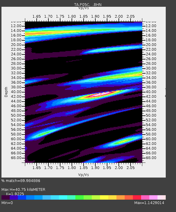
| Estimated Moho Depth: |
40.75 km |
| Estimated Crust Vp/Vs: |
1.92 |
| Assumed Crust Vp: |
6.597 km/s |
| Estimated Crust Vs: |
3.432 km/s |
| Estimated Crust Poisson's Ratio: |
0.31 |
|
| Radial Match: |
89.984886 % |
| Radial Bump: |
400 |
| Transverse Match: |
72.9925 % |
| Transverse Bump: |
400 |
| SOD ConfigId: |
2475 |
| Insert Time: |
2010-03-07 03:36:56.302 +0000 |
| GWidth: |
2.5 |
| Max Bumps: |
400 |
| Tol: |
0.001 |
|
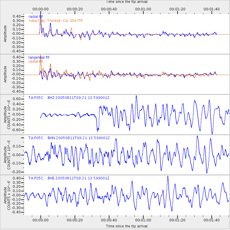
Signal To Noise
| Channel | StoN | STA | LTA |
| TA:P05C: :BHN:20050811T09:21:13.599001Z | 0.730148 | 3.3345337E-8 | 4.5669285E-8 |
| TA:P05C: :BHE:20050811T09:21:13.599001Z | 1.618048 | 9.667514E-8 | 5.974801E-8 |
| TA:P05C: :BHZ:20050811T09:21:13.599001Z | 6.9979534 | 2.693362E-7 | 3.848785E-8 |
| Arrivals |
| Ps | 5.8 SECOND |
| PpPs | 18 SECOND |
| PsPs/PpSs | 24 SECOND |


