You are here: Home > Network List > TA - USArray Transportable Network (new EarthScope stations) Stations List
> Station P05C Yuba Gap, Truckee, CA, USA > Earthquake Result Viewer
P05C Yuba Gap, Truckee, CA, USA - Earthquake Result Viewer

| Earthquake location: |
Near East Coast Of Honshu, Japan |
| Earthquake latitude/longitude: |
38.3/142.0 |
| Earthquake time(UTC): |
2005/08/16 (228) 02:46:28 GMT |
| Earthquake Depth: |
36 km |
| Earthquake Magnitude: |
6.5 MB, 6.8 MS, 7.2 MW, 7.1 MW |
| Earthquake Catalog/Contributor: |
WHDF/NEIC |
|
| Network: |
TA USArray Transportable Network (new EarthScope stations) |
| Station: |
P05C Yuba Gap, Truckee, CA, USA |
| Lat/Lon: |
39.30 N/120.61 W |
| Elevation: |
1756 m |
|
| Distance: |
71.9 deg |
| Az: |
54.063 deg |
| Baz: |
304.783 deg |
| Ray Param: |
0.05397623 |
| Estimated Moho Depth: |
44.25 km |
| Estimated Crust Vp/Vs: |
1.82 |
| Assumed Crust Vp: |
6.597 km/s |
| Estimated Crust Vs: |
3.63 km/s |
| Estimated Crust Poisson's Ratio: |
0.28 |
|
| Radial Match: |
95.769165 % |
| Radial Bump: |
311 |
| Transverse Match: |
85.481346 % |
| Transverse Bump: |
400 |
| SOD ConfigId: |
2475 |
| Insert Time: |
2010-03-07 03:36:58.988 +0000 |
| GWidth: |
2.5 |
| Max Bumps: |
400 |
| Tol: |
0.001 |
|
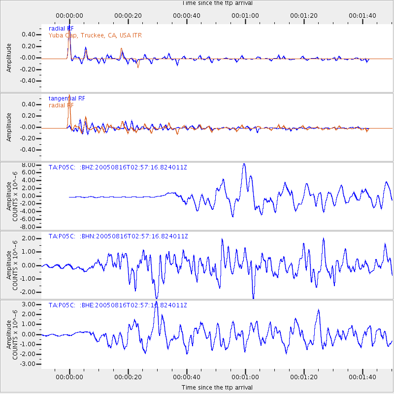
Signal To Noise
| Channel | StoN | STA | LTA |
| TA:P05C: :BHN:20050816T02:57:16.824011Z | 3.2423308 | 1.6541141E-7 | 5.10162E-8 |
| TA:P05C: :BHE:20050816T02:57:16.824011Z | 4.6879573 | 2.1105694E-7 | 4.502109E-8 |
| TA:P05C: :BHZ:20050816T02:57:16.824011Z | 9.603388 | 6.267976E-7 | 6.526839E-8 |
| Arrivals |
| Ps | 5.7 SECOND |
| PpPs | 18 SECOND |
| PsPs/PpSs | 24 SECOND |


