You are here: Home > Network List > TA - USArray Transportable Network (new EarthScope stations) Stations List
> Station B18K Kokolik River, AK, USA > Earthquake Result Viewer
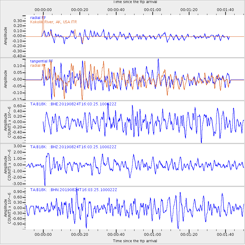
B18K Kokolik River, AK, USA - Earthquake Result Viewer
*The percent match for this event was below the threshold and hence no stack was calculated.
| Earthquake location: |
Vanuatu Islands |
| Earthquake latitude/longitude: |
-14.3/167.2 |
| Earthquake time(UTC): |
2019/08/24 (236) 15:51:27 GMT |
| Earthquake Depth: |
115 km |
| Earthquake Magnitude: |
6.0 Mww |
| Earthquake Catalog/Contributor: |
NEIC PDE/us |
|
| Network: |
TA USArray Transportable Network (new EarthScope stations) |
| Station: |
B18K Kokolik River, AK, USA |
| Lat/Lon: |
69.36 N/161.80 W |
| Elevation: |
222 m |
|
| Distance: |
86.3 deg |
| Az: |
10.55 deg |
| Baz: |
210.042 deg |
| Ray Param: |
$rayparam |
*The percent match for this event was below the threshold and hence was not used in the summary stack. |
|
| Radial Match: |
71.24231 % |
| Radial Bump: |
400 |
| Transverse Match: |
58.50875 % |
| Transverse Bump: |
400 |
| SOD ConfigId: |
19053131 |
| Insert Time: |
2019-09-07 16:00:41.199 +0000 |
| GWidth: |
2.5 |
| Max Bumps: |
400 |
| Tol: |
0.001 |
|
Signal To Noise
| Channel | StoN | STA | LTA |
| TA:B18K: :BHZ:20190824T16:03:25.100022Z | 5.3341684 | 1.382458E-6 | 2.591703E-7 |
| TA:B18K: :BHN:20190824T16:03:25.100022Z | 0.78821576 | 1.4807726E-7 | 1.8786386E-7 |
| TA:B18K: :BHE:20190824T16:03:25.100022Z | 1.2126213 | 2.308814E-7 | 1.903986E-7 |
| Arrivals |
| Ps | |
| PpPs | |
| PsPs/PpSs | |


