You are here: Home > Network List > TA - USArray Transportable Network (new EarthScope stations) Stations List
> Station D22K Ayikyak River, AK, USA > Earthquake Result Viewer
D22K Ayikyak River, AK, USA - Earthquake Result Viewer
| Earthquake location: |
Vanuatu Islands |
| Earthquake latitude/longitude: |
-14.3/167.2 |
| Earthquake time(UTC): |
2019/08/24 (236) 15:51:27 GMT |
| Earthquake Depth: |
115 km |
| Earthquake Magnitude: |
6.0 Mww |
| Earthquake Catalog/Contributor: |
NEIC PDE/us |
|
| Network: |
TA USArray Transportable Network (new EarthScope stations) |
| Station: |
D22K Ayikyak River, AK, USA |
| Lat/Lon: |
68.88 N/152.68 W |
| Elevation: |
532 m |
|
| Distance: |
87.7 deg |
| Az: |
13.523 deg |
| Baz: |
218.712 deg |
| Ray Param: |
0.042860743 |
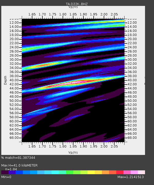
| Estimated Moho Depth: |
41.0 km |
| Estimated Crust Vp/Vs: |
1.84 |
| Assumed Crust Vp: |
6.221 km/s |
| Estimated Crust Vs: |
3.381 km/s |
| Estimated Crust Poisson's Ratio: |
0.29 |
|
| Radial Match: |
81.387344 % |
| Radial Bump: |
400 |
| Transverse Match: |
66.994606 % |
| Transverse Bump: |
400 |
| SOD ConfigId: |
19053131 |
| Insert Time: |
2019-09-07 16:00:49.096 +0000 |
| GWidth: |
2.5 |
| Max Bumps: |
400 |
| Tol: |
0.001 |
|

Signal To Noise
| Channel | StoN | STA | LTA |
| TA:D22K: :BHZ:20190824T16:03:32.049973Z | 5.626267 | 1.1588664E-6 | 2.059743E-7 |
| TA:D22K: :BHN:20190824T16:03:32.049973Z | 1.7740979 | 2.6529298E-7 | 1.4953683E-7 |
| TA:D22K: :BHE:20190824T16:03:32.049973Z | 2.3876748 | 3.8544246E-7 | 1.6143004E-7 |
| Arrivals |
| Ps | 5.6 SECOND |
| PpPs | 18 SECOND |
| PsPs/PpSs | 24 SECOND |


