You are here: Home > Network List > TA - USArray Transportable Network (new EarthScope stations) Stations List
> Station F15K North Star Ditch, AK, USA > Earthquake Result Viewer
F15K North Star Ditch, AK, USA - Earthquake Result Viewer
| Earthquake location: |
Vanuatu Islands |
| Earthquake latitude/longitude: |
-14.3/167.2 |
| Earthquake time(UTC): |
2019/08/24 (236) 15:51:27 GMT |
| Earthquake Depth: |
115 km |
| Earthquake Magnitude: |
6.0 Mww |
| Earthquake Catalog/Contributor: |
NEIC PDE/us |
|
| Network: |
TA USArray Transportable Network (new EarthScope stations) |
| Station: |
F15K North Star Ditch, AK, USA |
| Lat/Lon: |
65.71 N/164.65 W |
| Elevation: |
388 m |
|
| Distance: |
82.5 deg |
| Az: |
11.362 deg |
| Baz: |
207.491 deg |
| Ray Param: |
0.04655793 |
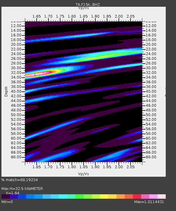
| Estimated Moho Depth: |
32.5 km |
| Estimated Crust Vp/Vs: |
1.64 |
| Assumed Crust Vp: |
6.276 km/s |
| Estimated Crust Vs: |
3.827 km/s |
| Estimated Crust Poisson's Ratio: |
0.20 |
|
| Radial Match: |
88.19234 % |
| Radial Bump: |
400 |
| Transverse Match: |
68.42921 % |
| Transverse Bump: |
400 |
| SOD ConfigId: |
19053131 |
| Insert Time: |
2019-09-07 16:01:03.589 +0000 |
| GWidth: |
2.5 |
| Max Bumps: |
400 |
| Tol: |
0.001 |
|

Signal To Noise
| Channel | StoN | STA | LTA |
| TA:F15K: :BHZ:20190824T16:03:06.299973Z | 9.843135 | 9.767978E-7 | 9.9236445E-8 |
| TA:F15K: :BHN:20190824T16:03:06.299973Z | 4.6427965 | 3.2862295E-7 | 7.0781255E-8 |
| TA:F15K: :BHE:20190824T16:03:06.299973Z | 2.3628943 | 1.3876462E-7 | 5.872655E-8 |
| Arrivals |
| Ps | 3.4 SECOND |
| PpPs | 13 SECOND |
| PsPs/PpSs | 17 SECOND |


