You are here: Home > Network List > TA - USArray Transportable Network (new EarthScope stations) Stations List
> Station G16K Koyuk River, AK, USA > Earthquake Result Viewer
G16K Koyuk River, AK, USA - Earthquake Result Viewer
| Earthquake location: |
Vanuatu Islands |
| Earthquake latitude/longitude: |
-14.3/167.2 |
| Earthquake time(UTC): |
2019/08/24 (236) 15:51:27 GMT |
| Earthquake Depth: |
115 km |
| Earthquake Magnitude: |
6.0 Mww |
| Earthquake Catalog/Contributor: |
NEIC PDE/us |
|
| Network: |
TA USArray Transportable Network (new EarthScope stations) |
| Station: |
G16K Koyuk River, AK, USA |
| Lat/Lon: |
65.39 N/162.35 W |
| Elevation: |
169 m |
|
| Distance: |
82.7 deg |
| Az: |
12.359 deg |
| Baz: |
209.704 deg |
| Ray Param: |
0.046433613 |
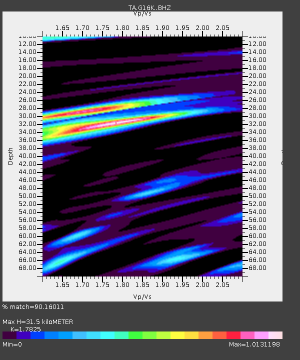
| Estimated Moho Depth: |
31.5 km |
| Estimated Crust Vp/Vs: |
1.78 |
| Assumed Crust Vp: |
6.276 km/s |
| Estimated Crust Vs: |
3.521 km/s |
| Estimated Crust Poisson's Ratio: |
0.27 |
|
| Radial Match: |
90.16011 % |
| Radial Bump: |
394 |
| Transverse Match: |
77.33545 % |
| Transverse Bump: |
400 |
| SOD ConfigId: |
19053131 |
| Insert Time: |
2019-09-07 16:01:11.326 +0000 |
| GWidth: |
2.5 |
| Max Bumps: |
400 |
| Tol: |
0.001 |
|

Signal To Noise
| Channel | StoN | STA | LTA |
| TA:G16K: :BHZ:20190824T16:03:07.225022Z | 14.504113 | 1.0880169E-6 | 7.501437E-8 |
| TA:G16K: :BHN:20190824T16:03:07.225022Z | 4.8392024 | 3.8333565E-7 | 7.921463E-8 |
| TA:G16K: :BHE:20190824T16:03:07.225022Z | 4.326168 | 2.6655064E-7 | 6.161357E-8 |
| Arrivals |
| Ps | 4.0 SECOND |
| PpPs | 14 SECOND |
| PsPs/PpSs | 18 SECOND |


