You are here: Home > Network List > TA - USArray Transportable Network (new EarthScope stations) Stations List
> Station P05C Yuba Gap, Truckee, CA, USA > Earthquake Result Viewer
P05C Yuba Gap, Truckee, CA, USA - Earthquake Result Viewer
| Earthquake location: |
Andreanof Islands, Aleutian Is. |
| Earthquake latitude/longitude: |
51.8/-176.3 |
| Earthquake time(UTC): |
2007/07/13 (194) 21:54:43 GMT |
| Earthquake Depth: |
35 km |
| Earthquake Magnitude: |
5.7 MB, 5.6 MS, 6.0 MW, 5.9 MW |
| Earthquake Catalog/Contributor: |
WHDF/NEIC |
|
| Network: |
TA USArray Transportable Network (new EarthScope stations) |
| Station: |
P05C Yuba Gap, Truckee, CA, USA |
| Lat/Lon: |
39.30 N/120.61 W |
| Elevation: |
1756 m |
|
| Distance: |
40.0 deg |
| Az: |
85.691 deg |
| Baz: |
307.117 deg |
| Ray Param: |
0.07458679 |
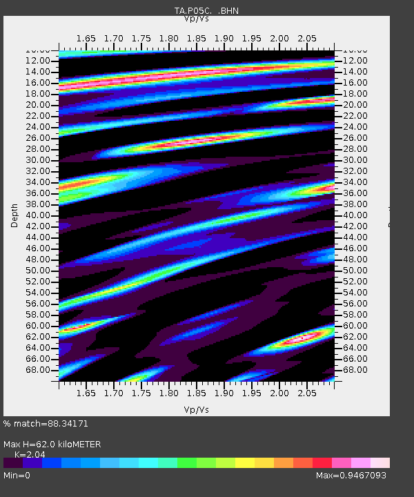
| Estimated Moho Depth: |
62.0 km |
| Estimated Crust Vp/Vs: |
2.04 |
| Assumed Crust Vp: |
6.597 km/s |
| Estimated Crust Vs: |
3.234 km/s |
| Estimated Crust Poisson's Ratio: |
0.34 |
|
| Radial Match: |
88.34171 % |
| Radial Bump: |
400 |
| Transverse Match: |
77.12342 % |
| Transverse Bump: |
400 |
| SOD ConfigId: |
2564 |
| Insert Time: |
2010-03-07 03:37:35.163 +0000 |
| GWidth: |
2.5 |
| Max Bumps: |
400 |
| Tol: |
0.001 |
|

Signal To Noise
| Channel | StoN | STA | LTA |
| TA:P05C: :BHN:20070713T22:01:43.925002Z | 3.9847312 | 1.5306124E-7 | 3.8411937E-8 |
| TA:P05C: :BHE:20070713T22:01:43.925002Z | 2.6280515 | 1.1928253E-7 | 4.53882E-8 |
| TA:P05C: :BHZ:20070713T22:01:43.925002Z | 5.4087143 | 3.4036196E-7 | 6.292844E-8 |
| Arrivals |
| Ps | 10 SECOND |
| PpPs | 27 SECOND |
| PsPs/PpSs | 37 SECOND |


