You are here: Home > Network List > TA - USArray Transportable Network (new EarthScope stations) Stations List
> Station J14K Nanvaranak Lake, AK, USA > Earthquake Result Viewer
J14K Nanvaranak Lake, AK, USA - Earthquake Result Viewer
| Earthquake location: |
Vanuatu Islands |
| Earthquake latitude/longitude: |
-14.3/167.2 |
| Earthquake time(UTC): |
2019/08/24 (236) 15:51:27 GMT |
| Earthquake Depth: |
115 km |
| Earthquake Magnitude: |
6.0 Mww |
| Earthquake Catalog/Contributor: |
NEIC PDE/us |
|
| Network: |
TA USArray Transportable Network (new EarthScope stations) |
| Station: |
J14K Nanvaranak Lake, AK, USA |
| Lat/Lon: |
62.75 N/163.55 W |
| Elevation: |
25 m |
|
| Distance: |
80.2 deg |
| Az: |
13.205 deg |
| Baz: |
208.753 deg |
| Ray Param: |
0.04821181 |
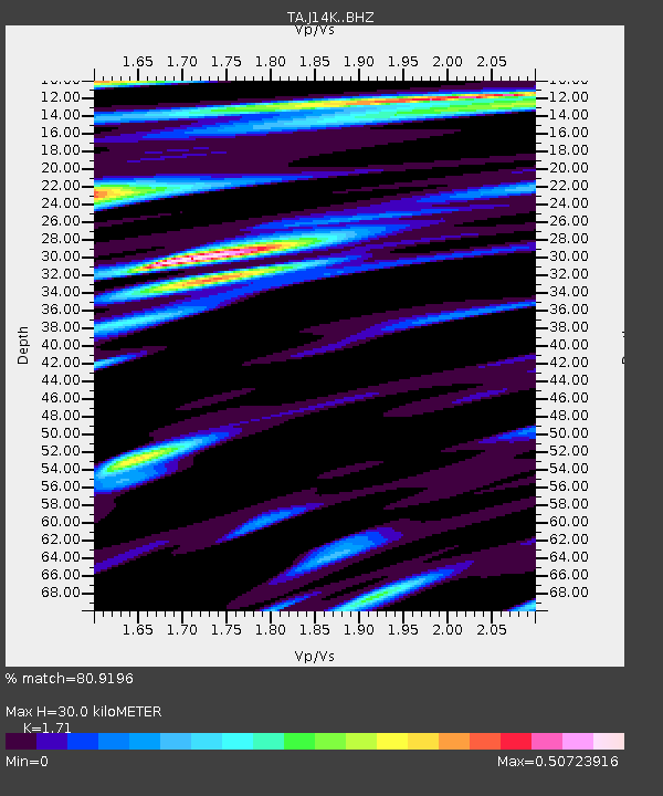
| Estimated Moho Depth: |
30.0 km |
| Estimated Crust Vp/Vs: |
1.71 |
| Assumed Crust Vp: |
6.155 km/s |
| Estimated Crust Vs: |
3.599 km/s |
| Estimated Crust Poisson's Ratio: |
0.24 |
|
| Radial Match: |
80.9196 % |
| Radial Bump: |
400 |
| Transverse Match: |
67.5794 % |
| Transverse Bump: |
400 |
| SOD ConfigId: |
19053131 |
| Insert Time: |
2019-09-07 16:01:31.664 +0000 |
| GWidth: |
2.5 |
| Max Bumps: |
400 |
| Tol: |
0.001 |
|

Signal To Noise
| Channel | StoN | STA | LTA |
| TA:J14K: :BHZ:20190824T16:02:53.699998Z | 9.716274 | 1.088465E-6 | 1.1202493E-7 |
| TA:J14K: :BHN:20190824T16:02:53.699998Z | 4.213615 | 3.1517555E-7 | 7.479933E-8 |
| TA:J14K: :BHE:20190824T16:02:53.699998Z | 1.8966539 | 1.8682091E-7 | 9.8500266E-8 |
| Arrivals |
| Ps | 3.6 SECOND |
| PpPs | 13 SECOND |
| PsPs/PpSs | 16 SECOND |


