You are here: Home > Network List > TA - USArray Transportable Network (new EarthScope stations) Stations List
> Station M16K Timber Creek, AK, USA > Earthquake Result Viewer
M16K Timber Creek, AK, USA - Earthquake Result Viewer
| Earthquake location: |
Vanuatu Islands |
| Earthquake latitude/longitude: |
-14.3/167.2 |
| Earthquake time(UTC): |
2019/08/24 (236) 15:51:27 GMT |
| Earthquake Depth: |
115 km |
| Earthquake Magnitude: |
6.0 Mww |
| Earthquake Catalog/Contributor: |
NEIC PDE/us |
|
| Network: |
TA USArray Transportable Network (new EarthScope stations) |
| Station: |
M16K Timber Creek, AK, USA |
| Lat/Lon: |
61.02 N/158.96 W |
| Elevation: |
394 m |
|
| Distance: |
79.8 deg |
| Az: |
16.005 deg |
| Baz: |
213.288 deg |
| Ray Param: |
0.048458412 |
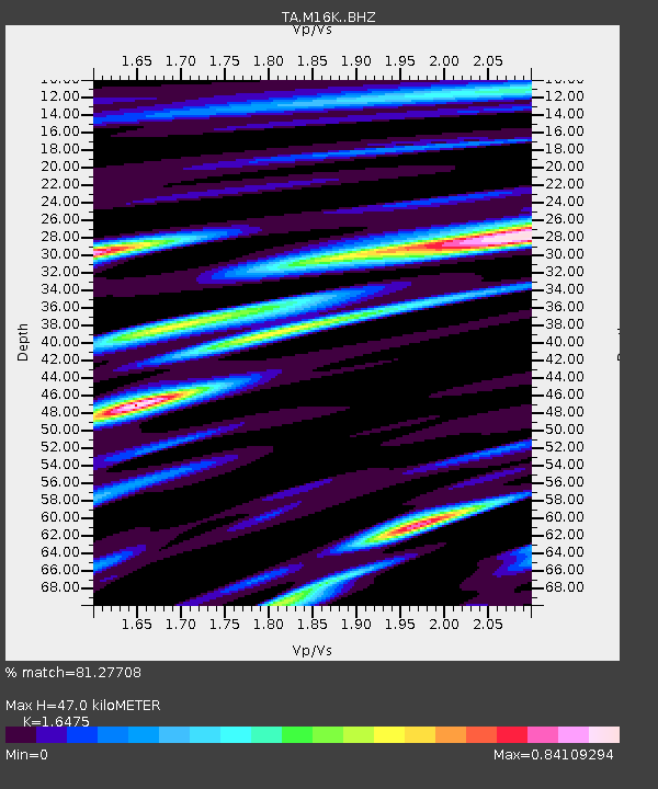
| Estimated Moho Depth: |
47.0 km |
| Estimated Crust Vp/Vs: |
1.65 |
| Assumed Crust Vp: |
6.276 km/s |
| Estimated Crust Vs: |
3.809 km/s |
| Estimated Crust Poisson's Ratio: |
0.21 |
|
| Radial Match: |
81.27708 % |
| Radial Bump: |
400 |
| Transverse Match: |
75.308784 % |
| Transverse Bump: |
400 |
| SOD ConfigId: |
19053131 |
| Insert Time: |
2019-09-07 16:01:48.965 +0000 |
| GWidth: |
2.5 |
| Max Bumps: |
400 |
| Tol: |
0.001 |
|

Signal To Noise
| Channel | StoN | STA | LTA |
| TA:M16K: :BHZ:20190824T16:02:51.77501Z | 6.182413 | 9.048668E-7 | 1.4636143E-7 |
| TA:M16K: :BHN:20190824T16:02:51.77501Z | 2.6150832 | 3.787836E-7 | 1.4484571E-7 |
| TA:M16K: :BHE:20190824T16:02:51.77501Z | 1.094772 | 2.527665E-7 | 2.3088506E-7 |
| Arrivals |
| Ps | 5.0 SECOND |
| PpPs | 19 SECOND |
| PsPs/PpSs | 24 SECOND |


