You are here: Home > Network List > TA - USArray Transportable Network (new EarthScope stations) Stations List
> Station P05C Yuba Gap, Truckee, CA, USA > Earthquake Result Viewer
P05C Yuba Gap, Truckee, CA, USA - Earthquake Result Viewer
| Earthquake location: |
Loyalty Islands |
| Earthquake latitude/longitude: |
-20.6/169.0 |
| Earthquake time(UTC): |
2007/04/03 (093) 20:26:09 GMT |
| Earthquake Depth: |
12 km |
| Earthquake Magnitude: |
5.6 MB, 6.0 MS, 6.2 MW, 6.1 MW |
| Earthquake Catalog/Contributor: |
WHDF/NEIC |
|
| Network: |
TA USArray Transportable Network (new EarthScope stations) |
| Station: |
P05C Yuba Gap, Truckee, CA, USA |
| Lat/Lon: |
39.30 N/120.61 W |
| Elevation: |
1756 m |
|
| Distance: |
88.7 deg |
| Az: |
46.98 deg |
| Baz: |
241.955 deg |
| Ray Param: |
0.04239266 |
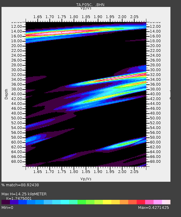
| Estimated Moho Depth: |
14.25 km |
| Estimated Crust Vp/Vs: |
1.75 |
| Assumed Crust Vp: |
6.597 km/s |
| Estimated Crust Vs: |
3.775 km/s |
| Estimated Crust Poisson's Ratio: |
0.26 |
|
| Radial Match: |
88.92438 % |
| Radial Bump: |
364 |
| Transverse Match: |
68.00478 % |
| Transverse Bump: |
400 |
| SOD ConfigId: |
2564 |
| Insert Time: |
2010-03-07 03:37:46.220 +0000 |
| GWidth: |
2.5 |
| Max Bumps: |
400 |
| Tol: |
0.001 |
|
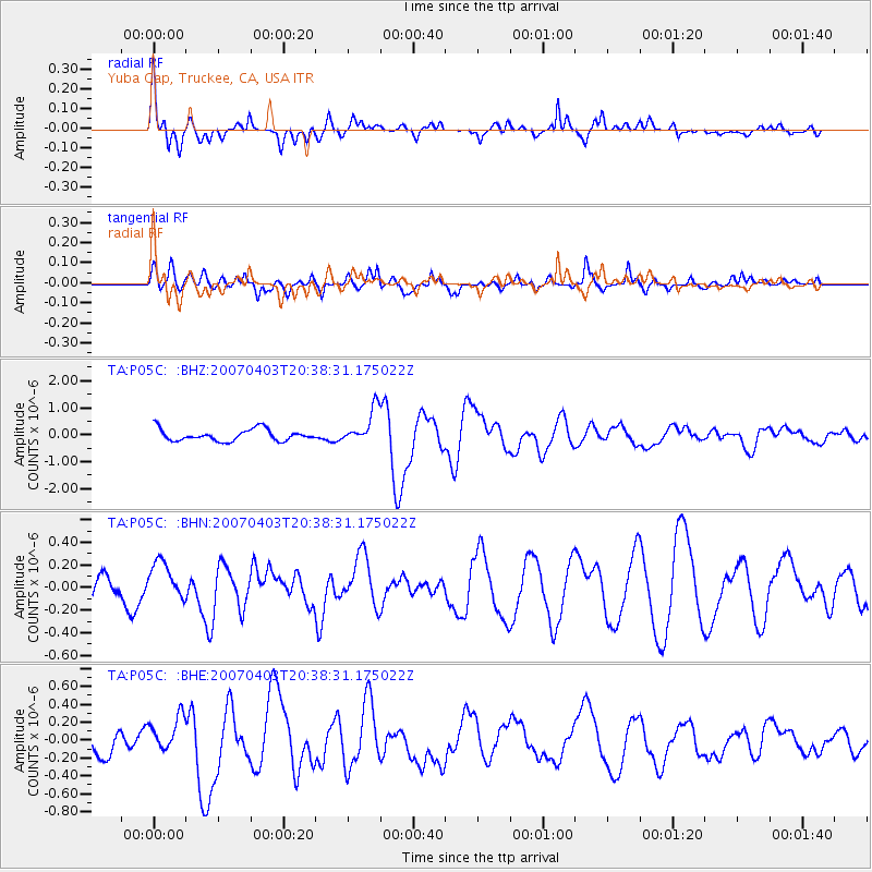
Signal To Noise
| Channel | StoN | STA | LTA |
| TA:P05C: :BHN:20070403T20:38:31.175022Z | 1.2666224 | 1.623304E-7 | 1.2816005E-7 |
| TA:P05C: :BHE:20070403T20:38:31.175022Z | 1.4210567 | 1.9889045E-7 | 1.3995952E-7 |
| TA:P05C: :BHZ:20070403T20:38:31.175022Z | 3.0492802 | 6.5165153E-7 | 2.1370667E-7 |
| Arrivals |
| Ps | 1.7 SECOND |
| PpPs | 5.8 SECOND |
| PsPs/PpSs | 7.5 SECOND |


