You are here: Home > Network List > TA - USArray Transportable Network (new EarthScope stations) Stations List
> Station P05C Yuba Gap, Truckee, CA, USA > Earthquake Result Viewer
P05C Yuba Gap, Truckee, CA, USA - Earthquake Result Viewer
| Earthquake location: |
Solomon Islands |
| Earthquake latitude/longitude: |
-7.3/155.4 |
| Earthquake time(UTC): |
2007/04/01 (091) 21:26:26 GMT |
| Earthquake Depth: |
10 km |
| Earthquake Magnitude: |
5.6 MB |
| Earthquake Catalog/Contributor: |
WHDF/NEIC |
|
| Network: |
TA USArray Transportable Network (new EarthScope stations) |
| Station: |
P05C Yuba Gap, Truckee, CA, USA |
| Lat/Lon: |
39.30 N/120.61 W |
| Elevation: |
1756 m |
|
| Distance: |
89.9 deg |
| Az: |
50.499 deg |
| Baz: |
260.615 deg |
| Ray Param: |
0.041710455 |
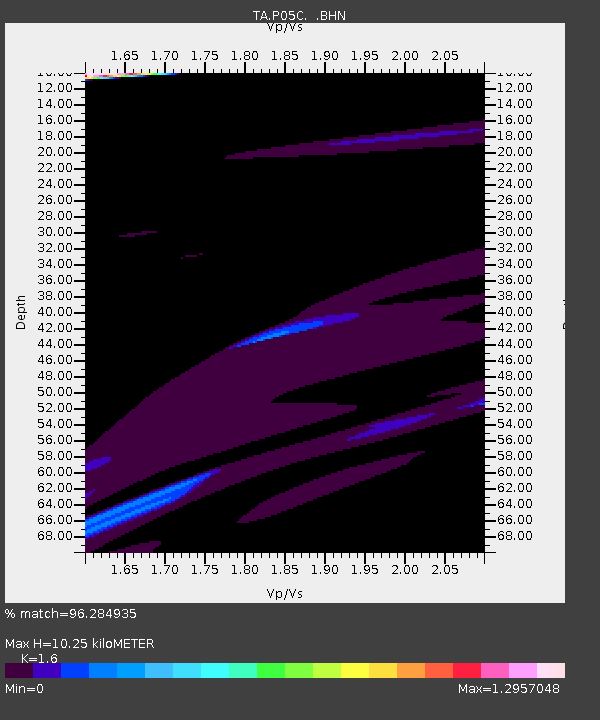
| Estimated Moho Depth: |
10.25 km |
| Estimated Crust Vp/Vs: |
1.60 |
| Assumed Crust Vp: |
6.597 km/s |
| Estimated Crust Vs: |
4.123 km/s |
| Estimated Crust Poisson's Ratio: |
0.18 |
|
| Radial Match: |
96.284935 % |
| Radial Bump: |
400 |
| Transverse Match: |
81.01029 % |
| Transverse Bump: |
399 |
| SOD ConfigId: |
2564 |
| Insert Time: |
2010-03-07 03:37:50.532 +0000 |
| GWidth: |
2.5 |
| Max Bumps: |
400 |
| Tol: |
0.001 |
|

Signal To Noise
| Channel | StoN | STA | LTA |
| TA:P05C: :BHN:20070401T21:38:54.150024Z | 1.1983747 | 1.9703875E-5 | 1.6442165E-5 |
| TA:P05C: :BHE:20070401T21:38:54.150024Z | 0.7497961 | 2.6273026E-5 | 3.504023E-5 |
| TA:P05C: :BHZ:20070401T21:38:54.150024Z | 0.89269435 | 2.9449926E-5 | 3.298993E-5 |
| Arrivals |
| Ps | 1.0 SECOND |
| PpPs | 3.9 SECOND |
| PsPs/PpSs | 4.9 SECOND |


