You are here: Home > Network List > TA - USArray Transportable Network (new EarthScope stations) Stations List
> Station P05C Yuba Gap, Truckee, CA, USA > Earthquake Result Viewer
P05C Yuba Gap, Truckee, CA, USA - Earthquake Result Viewer
| Earthquake location: |
San Juan Province, Argentina |
| Earthquake latitude/longitude: |
-31.7/-67.2 |
| Earthquake time(UTC): |
2006/09/17 (260) 09:34:14 GMT |
| Earthquake Depth: |
142 km |
| Earthquake Magnitude: |
5.7 MB, 6.2 MW, 6.2 MW |
| Earthquake Catalog/Contributor: |
WHDF/NEIC |
|
| Network: |
TA USArray Transportable Network (new EarthScope stations) |
| Station: |
P05C Yuba Gap, Truckee, CA, USA |
| Lat/Lon: |
39.30 N/120.61 W |
| Elevation: |
1756 m |
|
| Distance: |
86.4 deg |
| Az: |
321.361 deg |
| Baz: |
136.714 deg |
| Ray Param: |
0.04379131 |
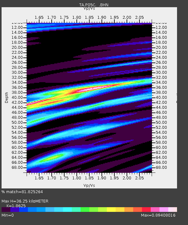
| Estimated Moho Depth: |
36.25 km |
| Estimated Crust Vp/Vs: |
1.86 |
| Assumed Crust Vp: |
6.597 km/s |
| Estimated Crust Vs: |
3.542 km/s |
| Estimated Crust Poisson's Ratio: |
0.30 |
|
| Radial Match: |
81.825264 % |
| Radial Bump: |
400 |
| Transverse Match: |
71.66143 % |
| Transverse Bump: |
400 |
| SOD ConfigId: |
2665 |
| Insert Time: |
2010-03-07 03:38:34.190 +0000 |
| GWidth: |
2.5 |
| Max Bumps: |
400 |
| Tol: |
0.001 |
|

Signal To Noise
| Channel | StoN | STA | LTA |
| TA:P05C: :BHN:20060917T09:46:09.049014Z | 2.53407 | 2.4699614E-7 | 9.747012E-8 |
| TA:P05C: :BHE:20060917T09:46:09.049014Z | 4.5610347 | 3.1847094E-7 | 6.982427E-8 |
| TA:P05C: :BHZ:20060917T09:46:09.049014Z | 12.163862 | 1.1024676E-6 | 9.063468E-8 |
| Arrivals |
| Ps | 4.8 SECOND |
| PpPs | 15 SECOND |
| PsPs/PpSs | 20 SECOND |


