You are here: Home > Network List > TA - USArray Transportable Network (new EarthScope stations) Stations List
> Station P05C Yuba Gap, Truckee, CA, USA > Earthquake Result Viewer
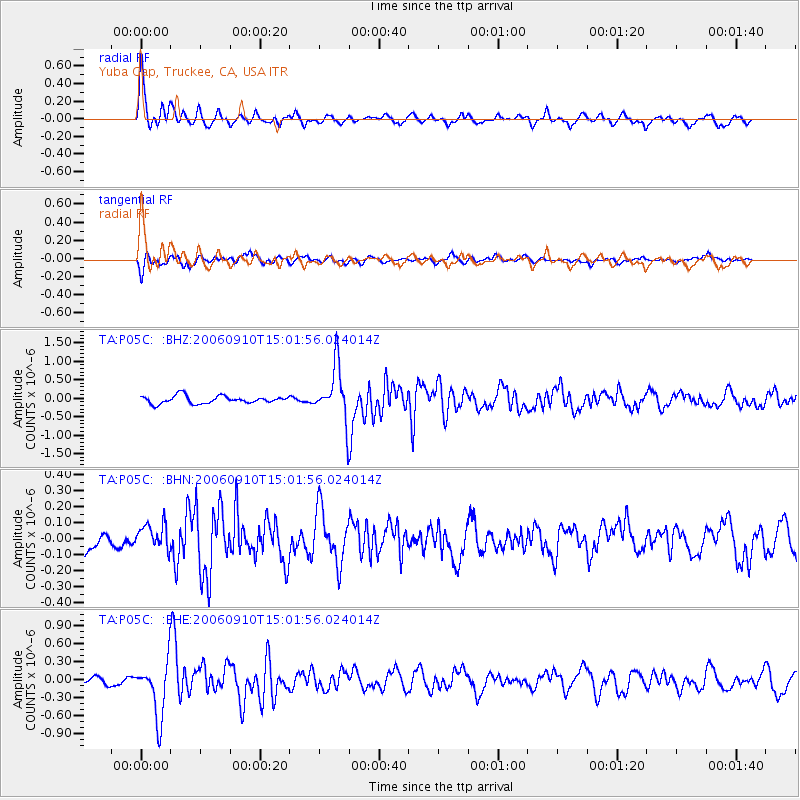
P05C Yuba Gap, Truckee, CA, USA - Earthquake Result Viewer

| Earthquake location: |
Gulf Of Mexico |
| Earthquake latitude/longitude: |
26.3/-86.6 |
| Earthquake time(UTC): |
2006/09/10 (253) 14:56:08 GMT |
| Earthquake Depth: |
14 km |
| Earthquake Magnitude: |
5.9 MB, 5.5 MS, 5.8 MW, 5.8 MW |
| Earthquake Catalog/Contributor: |
WHDF/NEIC |
|
| Network: |
TA USArray Transportable Network (new EarthScope stations) |
| Station: |
P05C Yuba Gap, Truckee, CA, USA |
| Lat/Lon: |
39.30 N/120.61 W |
| Elevation: |
1756 m |
|
| Distance: |
31.2 deg |
| Az: |
303.074 deg |
| Baz: |
104.227 deg |
| Ray Param: |
0.07913118 |
| Estimated Moho Depth: |
30.75 km |
| Estimated Crust Vp/Vs: |
2.03 |
| Assumed Crust Vp: |
6.597 km/s |
| Estimated Crust Vs: |
3.246 km/s |
| Estimated Crust Poisson's Ratio: |
0.34 |
|
| Radial Match: |
80.904564 % |
| Radial Bump: |
400 |
| Transverse Match: |
77.61438 % |
| Transverse Bump: |
400 |
| SOD ConfigId: |
2665 |
| Insert Time: |
2010-03-07 03:38:35.635 +0000 |
| GWidth: |
2.5 |
| Max Bumps: |
400 |
| Tol: |
0.001 |
|
Signal To Noise
| Channel | StoN | STA | LTA |
| TA:P05C: :BHN:20060910T15:01:56.024014Z | 1.0419731 | 7.728506E-8 | 7.417183E-8 |
| TA:P05C: :BHE:20060910T15:01:56.024014Z | 5.1891413 | 4.631754E-7 | 8.925859E-8 |
| TA:P05C: :BHZ:20060910T15:01:56.024014Z | 7.1140113 | 7.2374837E-7 | 1.0173562E-7 |
| Arrivals |
| Ps | 5.2 SECOND |
| PpPs | 13 SECOND |
| PsPs/PpSs | 18 SECOND |


