You are here: Home > Network List > TA - USArray Transportable Network (new EarthScope stations) Stations List
> Station P05C Yuba Gap, Truckee, CA, USA > Earthquake Result Viewer
P05C Yuba Gap, Truckee, CA, USA - Earthquake Result Viewer
| Earthquake location: |
Bonin Islands, Japan Region |
| Earthquake latitude/longitude: |
26.1/144.0 |
| Earthquake time(UTC): |
2006/08/06 (218) 18:16:40 GMT |
| Earthquake Depth: |
23 km |
| Earthquake Magnitude: |
6.0 MB, 5.6 MS, 5.8 MW, 5.8 MW |
| Earthquake Catalog/Contributor: |
WHDF/NEIC |
|
| Network: |
TA USArray Transportable Network (new EarthScope stations) |
| Station: |
P05C Yuba Gap, Truckee, CA, USA |
| Lat/Lon: |
39.30 N/120.61 W |
| Elevation: |
1756 m |
|
| Distance: |
77.8 deg |
| Az: |
52.206 deg |
| Baz: |
293.703 deg |
| Ray Param: |
0.050029285 |
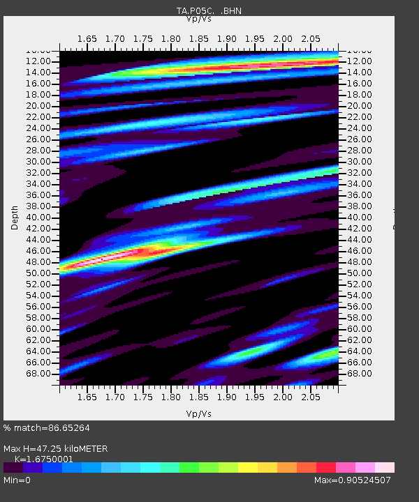
| Estimated Moho Depth: |
47.25 km |
| Estimated Crust Vp/Vs: |
1.68 |
| Assumed Crust Vp: |
6.597 km/s |
| Estimated Crust Vs: |
3.939 km/s |
| Estimated Crust Poisson's Ratio: |
0.22 |
|
| Radial Match: |
86.65264 % |
| Radial Bump: |
400 |
| Transverse Match: |
70.82494 % |
| Transverse Bump: |
400 |
| SOD ConfigId: |
2665 |
| Insert Time: |
2010-03-07 03:38:44.343 +0000 |
| GWidth: |
2.5 |
| Max Bumps: |
400 |
| Tol: |
0.001 |
|
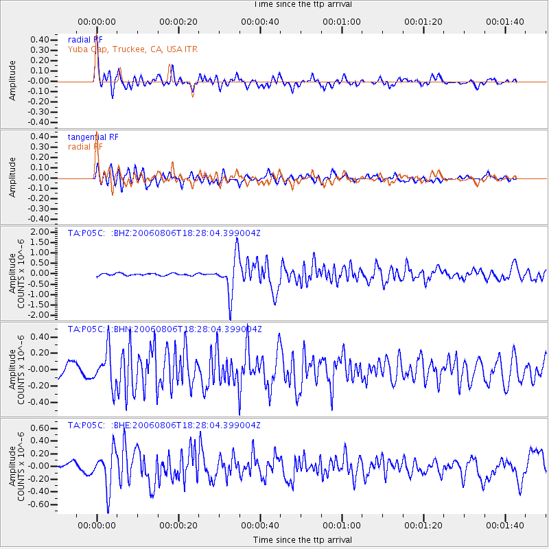
Signal To Noise
| Channel | StoN | STA | LTA |
| TA:P05C: :BHN:20060806T18:28:04.399004Z | 2.6451151 | 2.2479742E-7 | 8.498587E-8 |
| TA:P05C: :BHE:20060806T18:28:04.399004Z | 5.775569 | 2.9863324E-7 | 5.1706287E-8 |
| TA:P05C: :BHZ:20060806T18:28:04.399004Z | 18.940735 | 9.537954E-7 | 5.0356828E-8 |
| Arrivals |
| Ps | 5.0 SECOND |
| PpPs | 19 SECOND |
| PsPs/PpSs | 24 SECOND |


