You are here: Home > Network List > TA - USArray Transportable Network (new EarthScope stations) Stations List
> Station P05C Yuba Gap, Truckee, CA, USA > Earthquake Result Viewer
P05C Yuba Gap, Truckee, CA, USA - Earthquake Result Viewer
| Earthquake location: |
Off Coast Of Central Chile |
| Earthquake latitude/longitude: |
-28.7/-72.5 |
| Earthquake time(UTC): |
2006/07/16 (197) 11:42:41 GMT |
| Earthquake Depth: |
10 km |
| Earthquake Magnitude: |
5.9 MB, 5.7 MS, 6.2 MW, 6.2 MW |
| Earthquake Catalog/Contributor: |
WHDF/NEIC |
|
| Network: |
TA USArray Transportable Network (new EarthScope stations) |
| Station: |
P05C Yuba Gap, Truckee, CA, USA |
| Lat/Lon: |
39.30 N/120.61 W |
| Elevation: |
1756 m |
|
| Distance: |
81.1 deg |
| Az: |
324.257 deg |
| Baz: |
138.601 deg |
| Ray Param: |
0.047791764 |
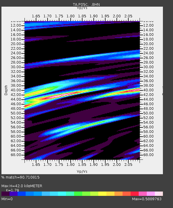
| Estimated Moho Depth: |
42.0 km |
| Estimated Crust Vp/Vs: |
1.76 |
| Assumed Crust Vp: |
6.597 km/s |
| Estimated Crust Vs: |
3.749 km/s |
| Estimated Crust Poisson's Ratio: |
0.26 |
|
| Radial Match: |
90.710815 % |
| Radial Bump: |
338 |
| Transverse Match: |
78.19466 % |
| Transverse Bump: |
400 |
| SOD ConfigId: |
2665 |
| Insert Time: |
2010-03-07 03:38:46.582 +0000 |
| GWidth: |
2.5 |
| Max Bumps: |
400 |
| Tol: |
0.001 |
|
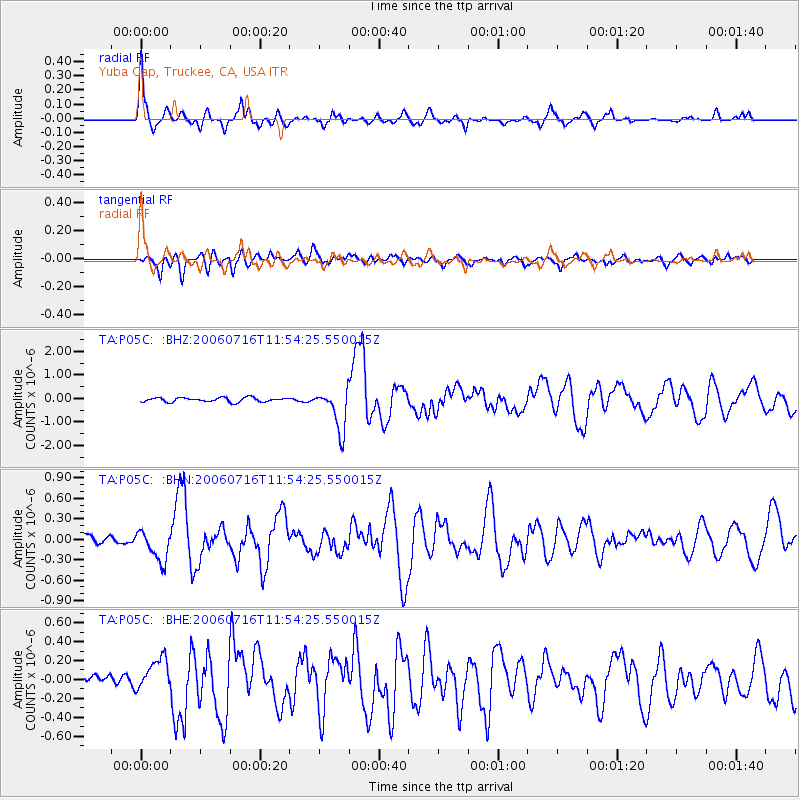
Signal To Noise
| Channel | StoN | STA | LTA |
| TA:P05C: :BHN:20060716T11:54:25.550015Z | 2.4334822 | 2.3213879E-7 | 9.5393666E-8 |
| TA:P05C: :BHE:20060716T11:54:25.550015Z | 2.6820579 | 1.7738923E-7 | 6.613923E-8 |
| TA:P05C: :BHZ:20060716T11:54:25.550015Z | 9.949877 | 8.897996E-7 | 8.94282E-8 |
| Arrivals |
| Ps | 5.0 SECOND |
| PpPs | 17 SECOND |
| PsPs/PpSs | 22 SECOND |


