You are here: Home > Network List > TA - USArray Transportable Network (new EarthScope stations) Stations List
> Station P05C Yuba Gap, Truckee, CA, USA > Earthquake Result Viewer
P05C Yuba Gap, Truckee, CA, USA - Earthquake Result Viewer
| Earthquake location: |
Rat Islands, Aleutian Islands |
| Earthquake latitude/longitude: |
51.7/176.9 |
| Earthquake time(UTC): |
2006/07/02 (183) 03:53:56 GMT |
| Earthquake Depth: |
8.6 km |
| Earthquake Magnitude: |
5.5 MB, 5.3 MS, 5.8 MW, 5.7 MW |
| Earthquake Catalog/Contributor: |
WHDF/NEIC |
|
| Network: |
TA USArray Transportable Network (new EarthScope stations) |
| Station: |
P05C Yuba Gap, Truckee, CA, USA |
| Lat/Lon: |
39.30 N/120.61 W |
| Elevation: |
1756 m |
|
| Distance: |
44.2 deg |
| Az: |
80.781 deg |
| Baz: |
307.673 deg |
| Ray Param: |
0.07207524 |
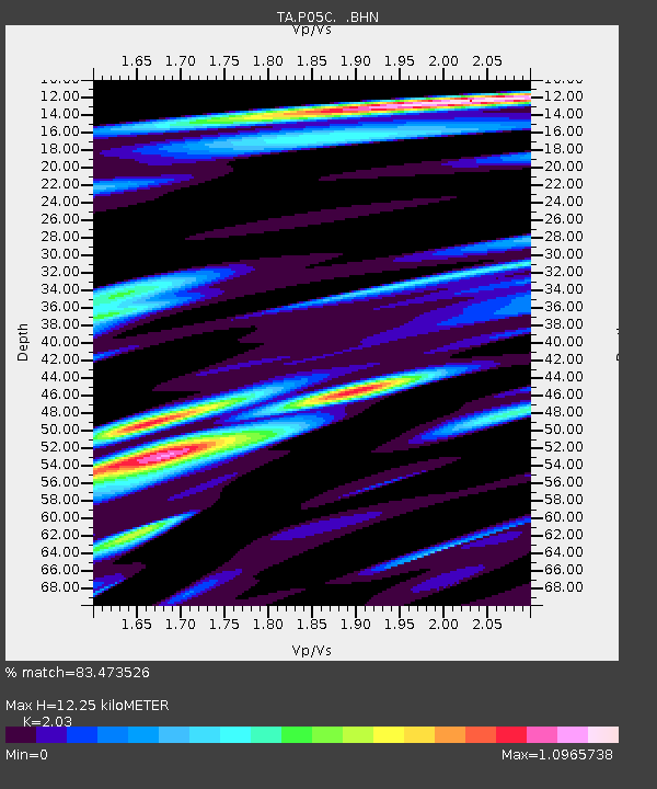
| Estimated Moho Depth: |
12.25 km |
| Estimated Crust Vp/Vs: |
2.03 |
| Assumed Crust Vp: |
6.597 km/s |
| Estimated Crust Vs: |
3.25 km/s |
| Estimated Crust Poisson's Ratio: |
0.34 |
|
| Radial Match: |
83.473526 % |
| Radial Bump: |
400 |
| Transverse Match: |
68.95964 % |
| Transverse Bump: |
400 |
| SOD ConfigId: |
2665 |
| Insert Time: |
2010-03-07 03:38:50.417 +0000 |
| GWidth: |
2.5 |
| Max Bumps: |
400 |
| Tol: |
0.001 |
|

Signal To Noise
| Channel | StoN | STA | LTA |
| TA:P05C: :BHN:20060702T04:01:34.775004Z | 1.848076 | 8.2611294E-8 | 4.4701242E-8 |
| TA:P05C: :BHE:20060702T04:01:34.775004Z | 1.4684052 | 5.913191E-8 | 4.0269477E-8 |
| TA:P05C: :BHZ:20060702T04:01:34.775004Z | 2.5018232 | 1.4412818E-7 | 5.7609256E-8 |
| Arrivals |
| Ps | 2.0 SECOND |
| PpPs | 5.3 SECOND |
| PsPs/PpSs | 7.3 SECOND |


