You are here: Home > Network List > TA - USArray Transportable Network (new EarthScope stations) Stations List
> Station P05C Yuba Gap, Truckee, CA, USA > Earthquake Result Viewer
P05C Yuba Gap, Truckee, CA, USA - Earthquake Result Viewer
| Earthquake location: |
Fox Islands, Aleutian Islands |
| Earthquake latitude/longitude: |
52.5/-169.3 |
| Earthquake time(UTC): |
2006/05/10 (130) 02:42:51 GMT |
| Earthquake Depth: |
18 km |
| Earthquake Magnitude: |
6.1 MB, 6.2 MS, 6.4 MW, 6.3 MW |
| Earthquake Catalog/Contributor: |
WHDF/NEIC |
|
| Network: |
TA USArray Transportable Network (new EarthScope stations) |
| Station: |
P05C Yuba Gap, Truckee, CA, USA |
| Lat/Lon: |
39.30 N/120.61 W |
| Elevation: |
1756 m |
|
| Distance: |
35.6 deg |
| Az: |
91.987 deg |
| Baz: |
308.078 deg |
| Ray Param: |
0.07709149 |
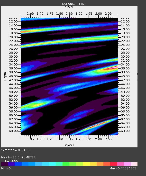
| Estimated Moho Depth: |
35.0 km |
| Estimated Crust Vp/Vs: |
2.10 |
| Assumed Crust Vp: |
6.597 km/s |
| Estimated Crust Vs: |
3.149 km/s |
| Estimated Crust Poisson's Ratio: |
0.35 |
|
| Radial Match: |
91.94098 % |
| Radial Bump: |
338 |
| Transverse Match: |
64.03225 % |
| Transverse Bump: |
400 |
| SOD ConfigId: |
2669 |
| Insert Time: |
2010-03-07 03:39:01.134 +0000 |
| GWidth: |
2.5 |
| Max Bumps: |
400 |
| Tol: |
0.001 |
|

Signal To Noise
| Channel | StoN | STA | LTA |
| TA:P05C: :BHN:20060510T02:49:17.125001Z | 0.5802263 | 1.0828969E-7 | 1.8663354E-7 |
| TA:P05C: :BHE:20060510T02:49:17.125001Z | 0.8691765 | 1.5151552E-7 | 1.7432077E-7 |
| TA:P05C: :BHZ:20060510T02:49:17.125001Z | 1.4640429 | 3.534754E-7 | 2.4143787E-7 |
| Arrivals |
| Ps | 6.2 SECOND |
| PpPs | 15 SECOND |
| PsPs/PpSs | 22 SECOND |


