You are here: Home > Network List > TA - USArray Transportable Network (new EarthScope stations) Stations List
> Station P05C Yuba Gap, Truckee, CA, USA > Earthquake Result Viewer
P05C Yuba Gap, Truckee, CA, USA - Earthquake Result Viewer
| Earthquake location: |
Near Coast Of Northern Chile |
| Earthquake latitude/longitude: |
-27.3/-71.2 |
| Earthquake time(UTC): |
2006/04/30 (120) 20:12:19 GMT |
| Earthquake Depth: |
20 km |
| Earthquake Magnitude: |
5.2 MB, 5.6 ML |
| Earthquake Catalog/Contributor: |
WHDF/NEIC |
|
| Network: |
TA USArray Transportable Network (new EarthScope stations) |
| Station: |
P05C Yuba Gap, Truckee, CA, USA |
| Lat/Lon: |
39.30 N/120.61 W |
| Elevation: |
1756 m |
|
| Distance: |
80.7 deg |
| Az: |
323.362 deg |
| Baz: |
136.799 deg |
| Ray Param: |
0.04809953 |
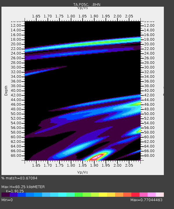
| Estimated Moho Depth: |
68.25 km |
| Estimated Crust Vp/Vs: |
1.91 |
| Assumed Crust Vp: |
6.597 km/s |
| Estimated Crust Vs: |
3.45 km/s |
| Estimated Crust Poisson's Ratio: |
0.31 |
|
| Radial Match: |
83.67094 % |
| Radial Bump: |
400 |
| Transverse Match: |
78.88458 % |
| Transverse Bump: |
400 |
| SOD ConfigId: |
2669 |
| Insert Time: |
2010-03-07 03:39:08.508 +0000 |
| GWidth: |
2.5 |
| Max Bumps: |
400 |
| Tol: |
0.001 |
|

Signal To Noise
| Channel | StoN | STA | LTA |
| TA:P05C: :BHN:20060430T20:23:59.125Z | 1.7997985 | 1.1881885E-6 | 6.6017867E-7 |
| TA:P05C: :BHE:20060430T20:23:59.125Z | 0.44954863 | 4.229586E-7 | 9.4085175E-7 |
| TA:P05C: :BHZ:20060430T20:23:59.125Z | 1.1209662 | 1.8956268E-6 | 1.691065E-6 |
| Arrivals |
| Ps | 9.7 SECOND |
| PpPs | 29 SECOND |
| PsPs/PpSs | 39 SECOND |


