You are here: Home > Network List > TA - USArray Transportable Network (new EarthScope stations) Stations List
> Station P05C Yuba Gap, Truckee, CA, USA > Earthquake Result Viewer
P05C Yuba Gap, Truckee, CA, USA - Earthquake Result Viewer
| Earthquake location: |
Fiji Islands Region |
| Earthquake latitude/longitude: |
-15.3/-176.2 |
| Earthquake time(UTC): |
2006/02/26 (057) 04:18:42 GMT |
| Earthquake Depth: |
32 km |
| Earthquake Magnitude: |
5.5 MB, 5.9 MS, 6.0 MW, 6.0 MW |
| Earthquake Catalog/Contributor: |
WHDF/NEIC |
|
| Network: |
TA USArray Transportable Network (new EarthScope stations) |
| Station: |
P05C Yuba Gap, Truckee, CA, USA |
| Lat/Lon: |
39.30 N/120.61 W |
| Elevation: |
1756 m |
|
| Distance: |
75.1 deg |
| Az: |
41.512 deg |
| Baz: |
235.527 deg |
| Ray Param: |
0.051859975 |
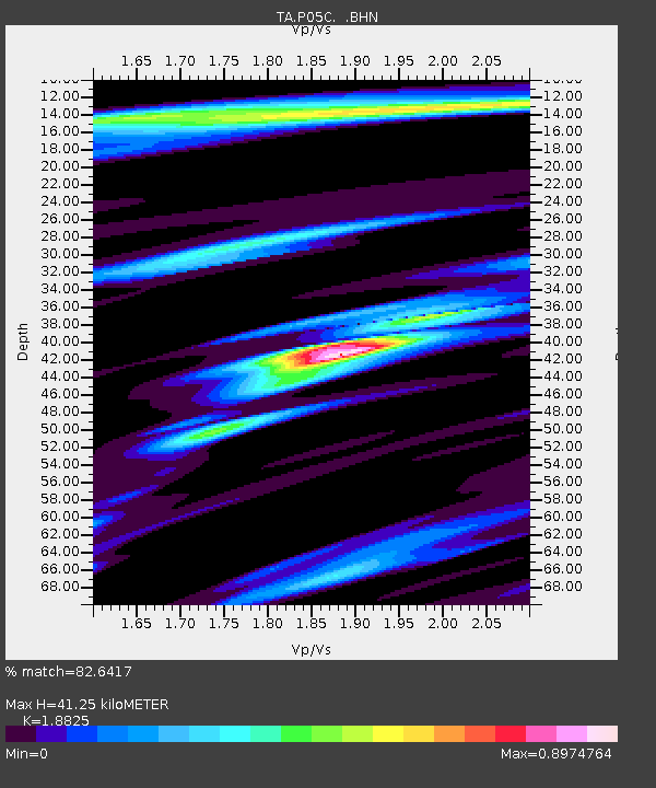
| Estimated Moho Depth: |
41.25 km |
| Estimated Crust Vp/Vs: |
1.88 |
| Assumed Crust Vp: |
6.597 km/s |
| Estimated Crust Vs: |
3.505 km/s |
| Estimated Crust Poisson's Ratio: |
0.30 |
|
| Radial Match: |
82.6417 % |
| Radial Bump: |
400 |
| Transverse Match: |
67.820625 % |
| Transverse Bump: |
400 |
| SOD ConfigId: |
132717 |
| Insert Time: |
2010-03-07 03:39:17.470 +0000 |
| GWidth: |
2.5 |
| Max Bumps: |
400 |
| Tol: |
0.001 |
|

Signal To Noise
| Channel | StoN | STA | LTA |
| TA:P05C: :BHN:20060226T04:29:49.700027Z | 0.9025983 | 1.1039261E-7 | 1.2230537E-7 |
| TA:P05C: :BHE:20060226T04:29:49.700027Z | 1.0240685 | 9.065203E-8 | 8.852146E-8 |
| TA:P05C: :BHZ:20060226T04:29:49.700027Z | 2.6487556 | 2.8680498E-7 | 1.0827913E-7 |
| Arrivals |
| Ps | 5.7 SECOND |
| PpPs | 17 SECOND |
| PsPs/PpSs | 23 SECOND |


