You are here: Home > Network List > TA - USArray Transportable Network (new EarthScope stations) Stations List
> Station P05C Yuba Gap, Truckee, CA, USA > Earthquake Result Viewer
P05C Yuba Gap, Truckee, CA, USA - Earthquake Result Viewer

| Earthquake location: |
Fiji Islands Region |
| Earthquake latitude/longitude: |
-18.0/-179.6 |
| Earthquake time(UTC): |
2006/02/24 (055) 14:15:45 GMT |
| Earthquake Depth: |
622 km |
| Earthquake Magnitude: |
5.9 MB, 6.1 MW, 6.0 MW |
| Earthquake Catalog/Contributor: |
WHDF/NEIC |
|
| Network: |
TA USArray Transportable Network (new EarthScope stations) |
| Station: |
P05C Yuba Gap, Truckee, CA, USA |
| Lat/Lon: |
39.30 N/120.61 W |
| Elevation: |
1756 m |
|
| Distance: |
79.2 deg |
| Az: |
42.598 deg |
| Baz: |
236.121 deg |
| Ray Param: |
0.04713501 |
| Estimated Moho Depth: |
41.75 km |
| Estimated Crust Vp/Vs: |
1.88 |
| Assumed Crust Vp: |
6.597 km/s |
| Estimated Crust Vs: |
3.514 km/s |
| Estimated Crust Poisson's Ratio: |
0.30 |
|
| Radial Match: |
90.022804 % |
| Radial Bump: |
400 |
| Transverse Match: |
81.86981 % |
| Transverse Bump: |
400 |
| SOD ConfigId: |
2422 |
| Insert Time: |
2010-03-07 03:39:18.985 +0000 |
| GWidth: |
2.5 |
| Max Bumps: |
400 |
| Tol: |
0.001 |
|
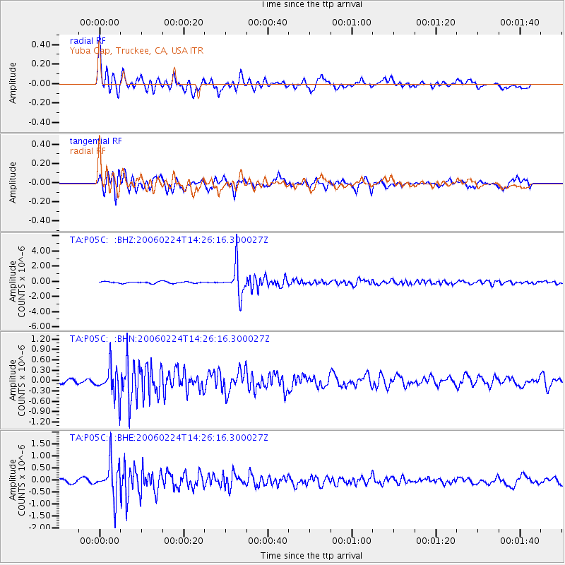
Signal To Noise
| Channel | StoN | STA | LTA |
| TA:P05C: :BHN:20060224T14:26:16.300027Z | 5.330946 | 4.3135873E-7 | 8.091599E-8 |
| TA:P05C: :BHE:20060224T14:26:16.300027Z | 7.473112 | 7.340442E-7 | 9.8224696E-8 |
| TA:P05C: :BHZ:20060224T14:26:16.300027Z | 17.748465 | 1.9583629E-6 | 1.1033985E-7 |
| Arrivals |
| Ps | 5.7 SECOND |
| PpPs | 18 SECOND |
| PsPs/PpSs | 23 SECOND |


