You are here: Home > Network List > TA - USArray Transportable Network (new EarthScope stations) Stations List
> Station J03A Ideyld Park, OR, USA > Earthquake Result Viewer
J03A Ideyld Park, OR, USA - Earthquake Result Viewer
| Earthquake location: |
South Of Fiji Islands |
| Earthquake latitude/longitude: |
-22.3/-179.5 |
| Earthquake time(UTC): |
2007/08/11 (223) 18:04:53 GMT |
| Earthquake Depth: |
606 km |
| Earthquake Magnitude: |
5.6 MW, 5.4 MB |
| Earthquake Catalog/Contributor: |
WHDF/NEIC |
|
| Network: |
TA USArray Transportable Network (new EarthScope stations) |
| Station: |
J03A Ideyld Park, OR, USA |
| Lat/Lon: |
43.72 N/122.96 W |
| Elevation: |
292 m |
|
| Distance: |
83.6 deg |
| Az: |
37.488 deg |
| Baz: |
231.034 deg |
| Ray Param: |
0.044244643 |
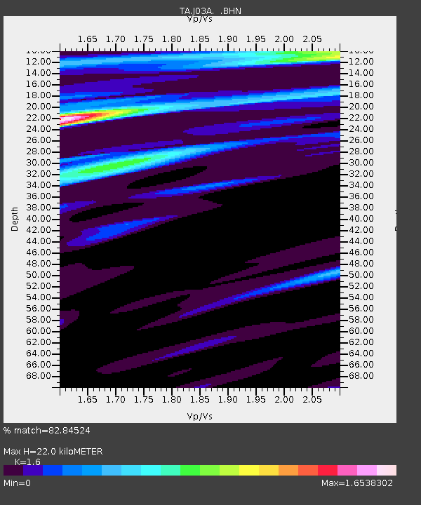
| Estimated Moho Depth: |
22.0 km |
| Estimated Crust Vp/Vs: |
1.60 |
| Assumed Crust Vp: |
6.522 km/s |
| Estimated Crust Vs: |
4.076 km/s |
| Estimated Crust Poisson's Ratio: |
0.18 |
|
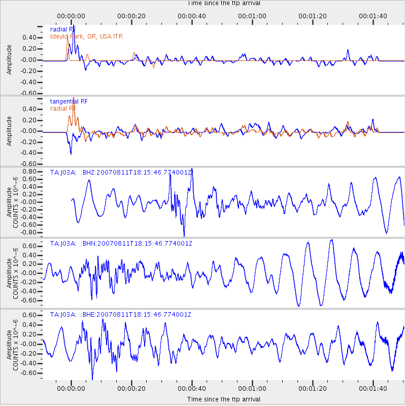
| Radial Match: |
82.84524 % |
| Radial Bump: |
400 |
| Transverse Match: |
65.8017 % |
| Transverse Bump: |
400 |
| SOD ConfigId: |
2564 |
| Insert Time: |
2010-03-07 03:39:23.795 +0000 |
| GWidth: |
2.5 |
| Max Bumps: |
400 |
| Tol: |
0.001 |
|
Signal To Noise
| Channel | StoN | STA | LTA |
| TA:J03A: :BHN:20070811T18:15:46.774001Z | 0.7570111 | 1.5307603E-7 | 2.0221108E-7 |
| TA:J03A: :BHE:20070811T18:15:46.774001Z | 1.9757466 | 2.4208E-7 | 1.2252585E-7 |
| TA:J03A: :BHZ:20070811T18:15:46.774001Z | 0.95704687 | 2.3995906E-7 | 2.5072868E-7 |
| Arrivals |
| Ps | 2.1 SECOND |
| PpPs | 8.5 SECOND |
| PsPs/PpSs | 11 SECOND |


