You are here: Home > Network List > CI - Caltech Regional Seismic Network Stations List
> Station MPM Manuel Prospect Mine, California, USA > Earthquake Result Viewer
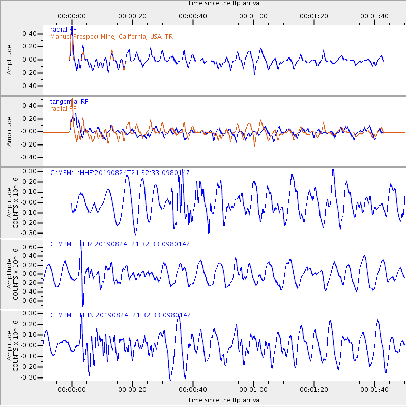
MPM Manuel Prospect Mine, California, USA - Earthquake Result Viewer
*The percent match for this event was below the threshold and hence no stack was calculated.
| Earthquake location: |
Tonga Islands |
| Earthquake latitude/longitude: |
-20.2/-175.6 |
| Earthquake time(UTC): |
2019/08/24 (236) 21:21:27 GMT |
| Earthquake Depth: |
215 km |
| Earthquake Magnitude: |
5.5 Mww |
| Earthquake Catalog/Contributor: |
NEIC PDE/us |
|
| Network: |
CI Caltech Regional Seismic Network |
| Station: |
MPM Manuel Prospect Mine, California, USA |
| Lat/Lon: |
36.06 N/117.49 W |
| Elevation: |
185 m |
|
| Distance: |
78.4 deg |
| Az: |
44.63 deg |
| Baz: |
234.528 deg |
| Ray Param: |
$rayparam |
*The percent match for this event was below the threshold and hence was not used in the summary stack. |
|
| Radial Match: |
61.931015 % |
| Radial Bump: |
400 |
| Transverse Match: |
62.00441 % |
| Transverse Bump: |
400 |
| SOD ConfigId: |
19053131 |
| Insert Time: |
2019-09-07 23:26:47.145 +0000 |
| GWidth: |
2.5 |
| Max Bumps: |
400 |
| Tol: |
0.001 |
|
Signal To Noise
| Channel | StoN | STA | LTA |
| CI:MPM: :HHZ:20190824T21:32:33.098014Z | 2.3906794 | 2.9674584E-7 | 1.2412616E-7 |
| CI:MPM: :HHN:20190824T21:32:33.098014Z | 1.0841305 | 9.1549815E-8 | 8.444538E-8 |
| CI:MPM: :HHE:20190824T21:32:33.098014Z | 0.80641323 | 1.0551669E-7 | 1.3084691E-7 |
| Arrivals |
| Ps | |
| PpPs | |
| PsPs/PpSs | |


