You are here: Home > Network List > TA - USArray Transportable Network (new EarthScope stations) Stations List
> Station J11A Camas Ranch, Mayfield, ID, USA > Earthquake Result Viewer
J11A Camas Ranch, Mayfield, ID, USA - Earthquake Result Viewer
| Earthquake location: |
Near Coast Of Northern Chile |
| Earthquake latitude/longitude: |
-20.2/-70.0 |
| Earthquake time(UTC): |
2008/02/04 (035) 17:01:30 GMT |
| Earthquake Depth: |
44 km |
| Earthquake Magnitude: |
6.0 MB, 6.2 MS, 6.3 MW, 6.3 MW |
| Earthquake Catalog/Contributor: |
WHDF/NEIC |
|
| Network: |
TA USArray Transportable Network (new EarthScope stations) |
| Station: |
J11A Camas Ranch, Mayfield, ID, USA |
| Lat/Lon: |
43.42 N/115.83 W |
| Elevation: |
1302 m |
|
| Distance: |
76.0 deg |
| Az: |
327.424 deg |
| Baz: |
136.042 deg |
| Ray Param: |
0.051242594 |
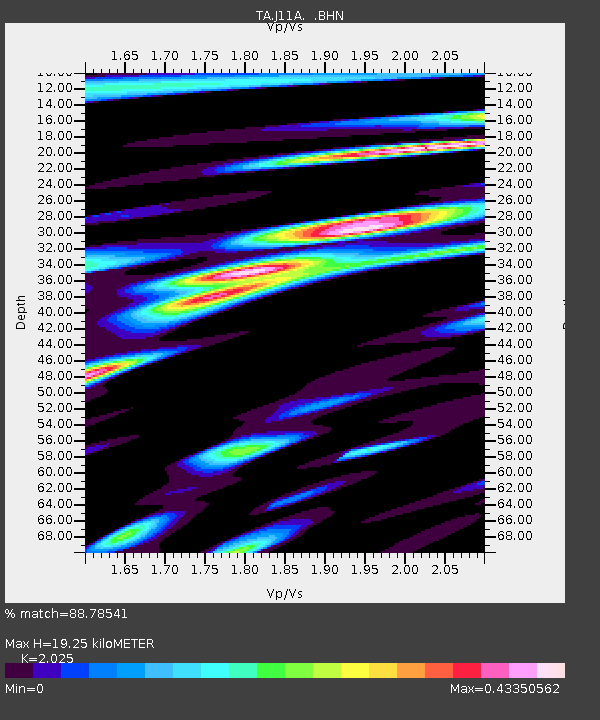
| Estimated Moho Depth: |
19.25 km |
| Estimated Crust Vp/Vs: |
2.03 |
| Assumed Crust Vp: |
6.291 km/s |
| Estimated Crust Vs: |
3.107 km/s |
| Estimated Crust Poisson's Ratio: |
0.34 |
|
| Radial Match: |
88.78541 % |
| Radial Bump: |
400 |
| Transverse Match: |
68.38954 % |
| Transverse Bump: |
400 |
| SOD ConfigId: |
2564 |
| Insert Time: |
2010-03-07 03:40:01.217 +0000 |
| GWidth: |
2.5 |
| Max Bumps: |
400 |
| Tol: |
0.001 |
|

Signal To Noise
| Channel | StoN | STA | LTA |
| TA:J11A: :BHN:20080204T17:12:42.350005Z | 3.0036125 | 8.636278E-7 | 2.875297E-7 |
| TA:J11A: :BHE:20080204T17:12:42.350005Z | 2.3667667 | 6.0907547E-7 | 2.5734496E-7 |
| TA:J11A: :BHZ:20080204T17:12:42.350005Z | 8.751433 | 2.7483359E-6 | 3.140441E-7 |
| Arrivals |
| Ps | 3.2 SECOND |
| PpPs | 9.0 SECOND |
| PsPs/PpSs | 12 SECOND |


