You are here: Home > Network List > TA - USArray Transportable Network (new EarthScope stations) Stations List
> Station J11A Camas Ranch, Mayfield, ID, USA > Earthquake Result Viewer
J11A Camas Ranch, Mayfield, ID, USA - Earthquake Result Viewer
| Earthquake location: |
Near S. Coast Of Honshu, Japan |
| Earthquake latitude/longitude: |
33.2/137.9 |
| Earthquake time(UTC): |
2009/08/09 (221) 10:55:55 GMT |
| Earthquake Depth: |
297 km |
| Earthquake Magnitude: |
6.5 MB, 7.1 MW, 7.1 MW |
| Earthquake Catalog/Contributor: |
WHDF/NEIC |
|
| Network: |
TA USArray Transportable Network (new EarthScope stations) |
| Station: |
J11A Camas Ranch, Mayfield, ID, USA |
| Lat/Lon: |
43.42 N/115.83 W |
| Elevation: |
1302 m |
|
| Distance: |
78.3 deg |
| Az: |
45.593 deg |
| Baz: |
304.686 deg |
| Ray Param: |
0.04890866 |
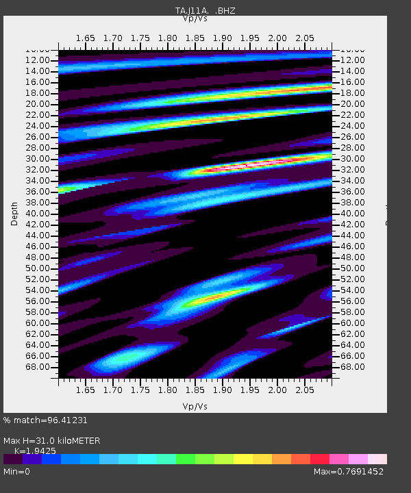
| Estimated Moho Depth: |
31.0 km |
| Estimated Crust Vp/Vs: |
1.94 |
| Assumed Crust Vp: |
6.291 km/s |
| Estimated Crust Vs: |
3.239 km/s |
| Estimated Crust Poisson's Ratio: |
0.32 |
|
| Radial Match: |
96.41231 % |
| Radial Bump: |
380 |
| Transverse Match: |
90.46115 % |
| Transverse Bump: |
400 |
| SOD ConfigId: |
2622 |
| Insert Time: |
2010-03-07 03:40:07.076 +0000 |
| GWidth: |
2.5 |
| Max Bumps: |
400 |
| Tol: |
0.001 |
|

Signal To Noise
| Channel | StoN | STA | LTA |
| TA:J11A: :BHZ:20090809T11:06:52.250015Z | 130.4401 | 1.0615428E-5 | 8.1381636E-8 |
| TA:J11A: :BHN:20090809T11:06:52.250015Z | 57.35492 | 2.7049596E-6 | 4.716177E-8 |
| TA:J11A: :BHE:20090809T11:06:52.250015Z | 60.03611 | 3.5410485E-6 | 5.8981982E-8 |
| Arrivals |
| Ps | 4.8 SECOND |
| PpPs | 14 SECOND |
| PsPs/PpSs | 19 SECOND |


