You are here: Home > Network List > TA - USArray Transportable Network (new EarthScope stations) Stations List
> Station J11A Camas Ranch, Mayfield, ID, USA > Earthquake Result Viewer
J11A Camas Ranch, Mayfield, ID, USA - Earthquake Result Viewer
| Earthquake location: |
Southwestern Ryukyu Isl., Japan |
| Earthquake latitude/longitude: |
23.5/123.5 |
| Earthquake time(UTC): |
2009/08/17 (229) 00:05:49 GMT |
| Earthquake Depth: |
20 km |
| Earthquake Magnitude: |
6.2 MB, 6.6 MS, 6.7 MW, 6.6 MW |
| Earthquake Catalog/Contributor: |
WHDF/NEIC |
|
| Network: |
TA USArray Transportable Network (new EarthScope stations) |
| Station: |
J11A Camas Ranch, Mayfield, ID, USA |
| Lat/Lon: |
43.42 N/115.83 W |
| Elevation: |
1302 m |
|
| Distance: |
94.0 deg |
| Az: |
38.923 deg |
| Baz: |
307.673 deg |
| Ray Param: |
0.041140866 |
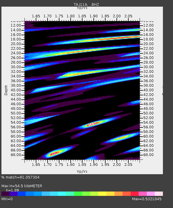
| Estimated Moho Depth: |
54.5 km |
| Estimated Crust Vp/Vs: |
1.89 |
| Assumed Crust Vp: |
6.291 km/s |
| Estimated Crust Vs: |
3.329 km/s |
| Estimated Crust Poisson's Ratio: |
0.31 |
|
| Radial Match: |
91.057304 % |
| Radial Bump: |
400 |
| Transverse Match: |
62.394306 % |
| Transverse Bump: |
400 |
| SOD ConfigId: |
2622 |
| Insert Time: |
2010-03-07 03:40:18.742 +0000 |
| GWidth: |
2.5 |
| Max Bumps: |
400 |
| Tol: |
0.001 |
|

Signal To Noise
| Channel | StoN | STA | LTA |
| TA:J11A: :BHZ:20090817T00:18:33.899019Z | 3.045503 | 2.1142272E-7 | 6.942128E-8 |
| TA:J11A: :BHN:20090817T00:18:33.899019Z | 1.0461009 | 6.3224455E-8 | 6.04382E-8 |
| TA:J11A: :BHE:20090817T00:18:33.899019Z | 1.3176727 | 9.373829E-8 | 7.113928E-8 |
| Arrivals |
| Ps | 7.9 SECOND |
| PpPs | 25 SECOND |
| PsPs/PpSs | 32 SECOND |


