You are here: Home > Network List > TA - USArray Transportable Network (new EarthScope stations) Stations List
> Station I23K Minto, Yukon-Koyukuk, AK, USA > Earthquake Result Viewer
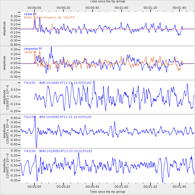
I23K Minto, Yukon-Koyukuk, AK, USA - Earthquake Result Viewer
*The percent match for this event was below the threshold and hence no stack was calculated.
| Earthquake location: |
Tonga Islands |
| Earthquake latitude/longitude: |
-20.2/-175.6 |
| Earthquake time(UTC): |
2019/08/24 (236) 21:21:27 GMT |
| Earthquake Depth: |
215 km |
| Earthquake Magnitude: |
5.5 Mww |
| Earthquake Catalog/Contributor: |
NEIC PDE/us |
|
| Network: |
TA USArray Transportable Network (new EarthScope stations) |
| Station: |
I23K Minto, Yukon-Koyukuk, AK, USA |
| Lat/Lon: |
65.15 N/149.36 W |
| Elevation: |
149 m |
|
| Distance: |
87.4 deg |
| Az: |
10.791 deg |
| Baz: |
204.593 deg |
| Ray Param: |
$rayparam |
*The percent match for this event was below the threshold and hence was not used in the summary stack. |
|
| Radial Match: |
53.41771 % |
| Radial Bump: |
400 |
| Transverse Match: |
59.431793 % |
| Transverse Bump: |
400 |
| SOD ConfigId: |
19053131 |
| Insert Time: |
2019-09-07 23:30:34.245 +0000 |
| GWidth: |
2.5 |
| Max Bumps: |
400 |
| Tol: |
0.001 |
|
Signal To Noise
| Channel | StoN | STA | LTA |
| TA:I23K: :BHZ:20190824T21:33:19.025016Z | 4.0535846 | 3.3041968E-7 | 8.151296E-8 |
| TA:I23K: :BHN:20190824T21:33:19.025016Z | 2.0054297 | 1.4248538E-7 | 7.10498E-8 |
| TA:I23K: :BHE:20190824T21:33:19.025016Z | 1.147928 | 8.9472024E-8 | 7.79422E-8 |
| Arrivals |
| Ps | |
| PpPs | |
| PsPs/PpSs | |


