You are here: Home > Network List > US - United States National Seismic Network Stations List
> Station AMTX Amarillo, Texas, USA > Earthquake Result Viewer
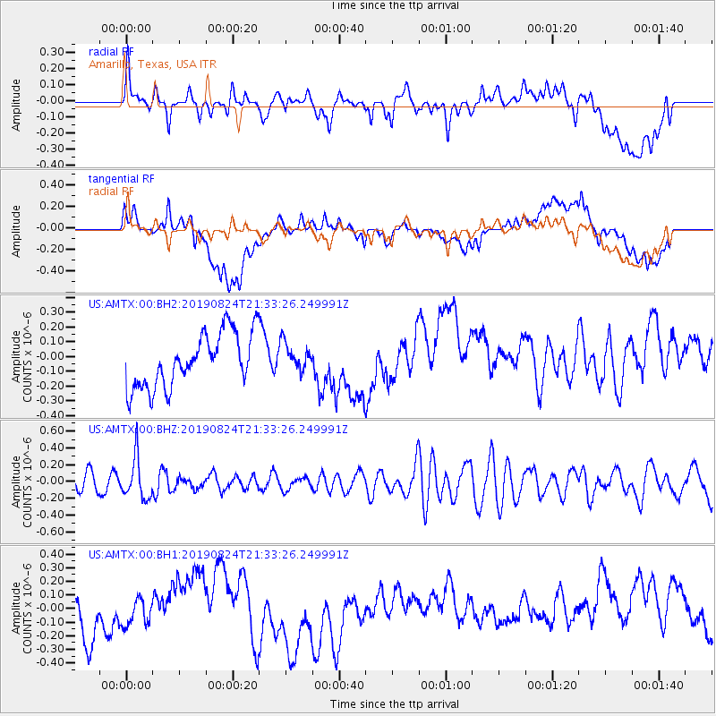
AMTX Amarillo, Texas, USA - Earthquake Result Viewer
*The percent match for this event was below the threshold and hence no stack was calculated.
| Earthquake location: |
Tonga Islands |
| Earthquake latitude/longitude: |
-20.2/-175.6 |
| Earthquake time(UTC): |
2019/08/24 (236) 21:21:27 GMT |
| Earthquake Depth: |
215 km |
| Earthquake Magnitude: |
5.5 Mww |
| Earthquake Catalog/Contributor: |
NEIC PDE/us |
|
| Network: |
US United States National Seismic Network |
| Station: |
AMTX Amarillo, Texas, USA |
| Lat/Lon: |
34.53 N/101.41 W |
| Elevation: |
1010 m |
|
| Distance: |
89.0 deg |
| Az: |
52.618 deg |
| Baz: |
244.698 deg |
| Ray Param: |
$rayparam |
*The percent match for this event was below the threshold and hence was not used in the summary stack. |
|
| Radial Match: |
41.356937 % |
| Radial Bump: |
400 |
| Transverse Match: |
22.836391 % |
| Transverse Bump: |
400 |
| SOD ConfigId: |
19053131 |
| Insert Time: |
2019-09-07 23:32:09.310 +0000 |
| GWidth: |
2.5 |
| Max Bumps: |
400 |
| Tol: |
0.001 |
|
Signal To Noise
| Channel | StoN | STA | LTA |
| US:AMTX:00:BHZ:20190824T21:33:26.249991Z | 2.4302542 | 2.429835E-7 | 9.9982756E-8 |
| US:AMTX:00:BH1:20190824T21:33:26.249991Z | 0.62319136 | 1.1497947E-7 | 1.8450106E-7 |
| US:AMTX:00:BH2:20190824T21:33:26.249991Z | 0.4725155 | 8.606903E-8 | 1.821507E-7 |
| Arrivals |
| Ps | |
| PpPs | |
| PsPs/PpSs | |


