You are here: Home > Network List > UU - University of Utah Regional Network Stations List
> Station TCRU Three Creek Reservoir, UT, USA > Earthquake Result Viewer
TCRU Three Creek Reservoir, UT, USA - Earthquake Result Viewer
| Earthquake location: |
Queen Elizabeth Islands, Canada |
| Earthquake latitude/longitude: |
74.3/-92.3 |
| Earthquake time(UTC): |
2017/01/08 (008) 23:47:12 GMT |
| Earthquake Depth: |
19 km |
| Earthquake Magnitude: |
5.8 Mwp |
| Earthquake Catalog/Contributor: |
NEIC PDE/us |
|
| Network: |
UU University of Utah Regional Network |
| Station: |
TCRU Three Creek Reservoir, UT, USA |
| Lat/Lon: |
38.61 N/112.45 W |
| Elevation: |
2293 m |
|
| Distance: |
37.1 deg |
| Az: |
206.596 deg |
| Baz: |
8.94 deg |
| Ray Param: |
0.07632265 |
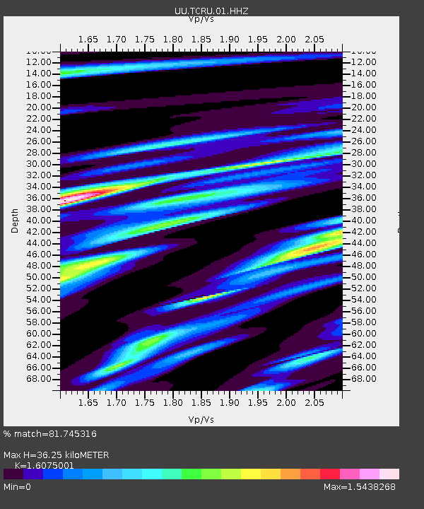
| Estimated Moho Depth: |
36.25 km |
| Estimated Crust Vp/Vs: |
1.61 |
| Assumed Crust Vp: |
6.276 km/s |
| Estimated Crust Vs: |
3.904 km/s |
| Estimated Crust Poisson's Ratio: |
0.18 |
|
| Radial Match: |
81.745316 % |
| Radial Bump: |
327 |
| Transverse Match: |
64.5808 % |
| Transverse Bump: |
400 |
| SOD ConfigId: |
1943534 |
| Insert Time: |
2017-01-22 23:53:57.152 +0000 |
| GWidth: |
2.5 |
| Max Bumps: |
400 |
| Tol: |
0.001 |
|

Signal To Noise
| Channel | StoN | STA | LTA |
| UU:TCRU:01:HHZ:20170108T23:53:50.510011Z | 1.6728731 | 1.0153925E-8 | 6.069752E-9 |
| UU:TCRU:01:HHN:20170108T23:53:50.510011Z | 1.2114106 | 6.453474E-9 | 5.327239E-9 |
| UU:TCRU:01:HHE:20170108T23:53:50.510011Z | 1.0782164 | 5.851571E-9 | 5.4270837E-9 |
| Arrivals |
| Ps | 3.8 SECOND |
| PpPs | 14 SECOND |
| PsPs/PpSs | 18 SECOND |


