You are here: Home > Network List > TA - USArray Transportable Network (new EarthScope stations) Stations List
> Station J11A Camas Ranch, Mayfield, ID, USA > Earthquake Result Viewer
J11A Camas Ranch, Mayfield, ID, USA - Earthquake Result Viewer
| Earthquake location: |
Kermadec Islands, New Zealand |
| Earthquake latitude/longitude: |
-29.8/-178.0 |
| Earthquake time(UTC): |
2007/01/31 (031) 03:15:52 GMT |
| Earthquake Depth: |
34 km |
| Earthquake Magnitude: |
6.1 MB, 6.3 MS, 6.5 MW, 6.4 MW |
| Earthquake Catalog/Contributor: |
WHDF/NEIC |
|
| Network: |
TA USArray Transportable Network (new EarthScope stations) |
| Station: |
J11A Camas Ranch, Mayfield, ID, USA |
| Lat/Lon: |
43.42 N/115.83 W |
| Elevation: |
1302 m |
|
| Distance: |
92.4 deg |
| Az: |
40.167 deg |
| Baz: |
230.316 deg |
| Ray Param: |
0.04144568 |
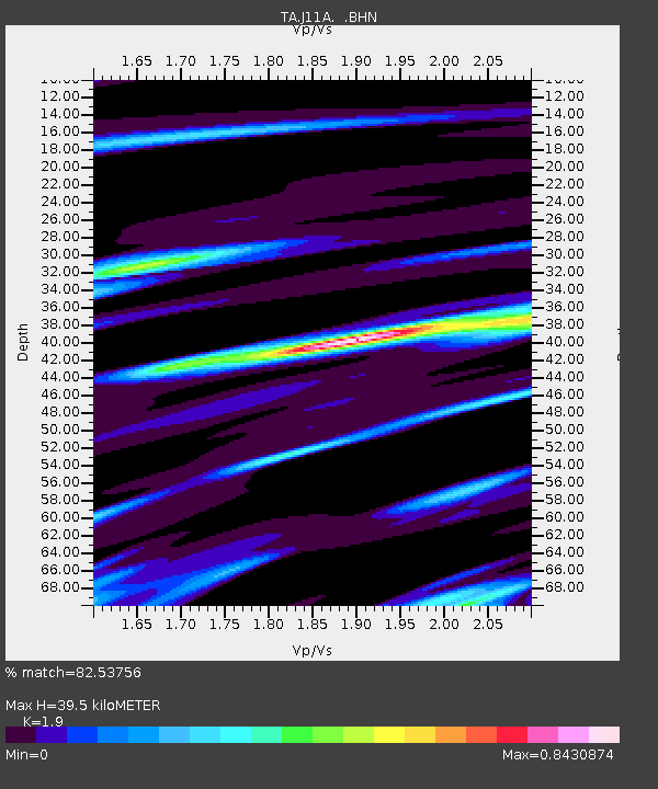
| Estimated Moho Depth: |
39.5 km |
| Estimated Crust Vp/Vs: |
1.90 |
| Assumed Crust Vp: |
6.291 km/s |
| Estimated Crust Vs: |
3.311 km/s |
| Estimated Crust Poisson's Ratio: |
0.31 |
|
| Radial Match: |
82.53756 % |
| Radial Bump: |
400 |
| Transverse Match: |
57.181385 % |
| Transverse Bump: |
400 |
| SOD ConfigId: |
2564 |
| Insert Time: |
2010-03-07 03:41:51.109 +0000 |
| GWidth: |
2.5 |
| Max Bumps: |
400 |
| Tol: |
0.001 |
|

Signal To Noise
| Channel | StoN | STA | LTA |
| TA:J11A: :BHN:20070131T03:28:28.32302Z | 1.0582346 | 2.7114012E-7 | 2.5621932E-7 |
| TA:J11A: :BHE:20070131T03:28:28.32302Z | 0.7910487 | 1.812515E-7 | 2.291281E-7 |
| TA:J11A: :BHZ:20070131T03:28:28.32302Z | 3.9695659 | 6.722792E-7 | 1.6935837E-7 |
| Arrivals |
| Ps | 5.8 SECOND |
| PpPs | 18 SECOND |
| PsPs/PpSs | 24 SECOND |


