You are here: Home > Network List > TA - USArray Transportable Network (new EarthScope stations) Stations List
> Station J11A Camas Ranch, Mayfield, ID, USA > Earthquake Result Viewer
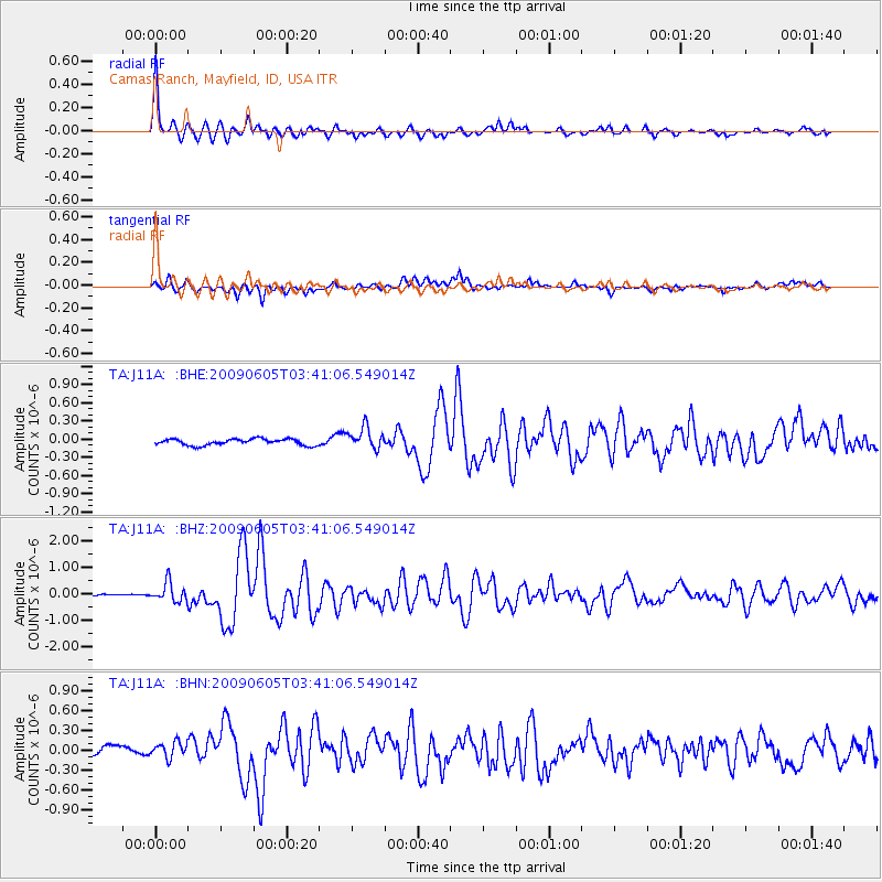
J11A Camas Ranch, Mayfield, ID, USA - Earthquake Result Viewer

| Earthquake location: |
Hokkaido, Japan Region |
| Earthquake latitude/longitude: |
41.8/143.4 |
| Earthquake time(UTC): |
2009/06/05 (156) 03:30:33 GMT |
| Earthquake Depth: |
29 km |
| Earthquake Magnitude: |
6.0 MB, 6.3 MS, 6.4 MW, 6.4 MW |
| Earthquake Catalog/Contributor: |
WHDF/NEIC |
|
| Network: |
TA USArray Transportable Network (new EarthScope stations) |
| Station: |
J11A Camas Ranch, Mayfield, ID, USA |
| Lat/Lon: |
43.42 N/115.83 W |
| Elevation: |
1302 m |
|
| Distance: |
69.3 deg |
| Az: |
49.943 deg |
| Baz: |
308.272 deg |
| Ray Param: |
0.05570266 |
| Estimated Moho Depth: |
31.25 km |
| Estimated Crust Vp/Vs: |
1.99 |
| Assumed Crust Vp: |
6.291 km/s |
| Estimated Crust Vs: |
3.165 km/s |
| Estimated Crust Poisson's Ratio: |
0.33 |
|
| Radial Match: |
93.37813 % |
| Radial Bump: |
368 |
| Transverse Match: |
83.035515 % |
| Transverse Bump: |
400 |
| SOD ConfigId: |
2648 |
| Insert Time: |
2010-03-07 03:41:59.767 +0000 |
| GWidth: |
2.5 |
| Max Bumps: |
400 |
| Tol: |
0.001 |
|
Signal To Noise
| Channel | StoN | STA | LTA |
| TA:J11A: :BHZ:20090605T03:41:06.549014Z | 6.8910484 | 3.592679E-7 | 5.2135444E-8 |
| TA:J11A: :BHN:20090605T03:41:06.549014Z | 1.876503 | 1.2630018E-7 | 6.7306146E-8 |
| TA:J11A: :BHE:20090605T03:41:06.549014Z | 3.382531 | 1.7553165E-7 | 5.1893583E-8 |
| Arrivals |
| Ps | 5.1 SECOND |
| PpPs | 14 SECOND |
| PsPs/PpSs | 19 SECOND |


