You are here: Home > Network List > G - GEOSCOPE Stations List
> Station MBO M'Bour, Senegal > Earthquake Result Viewer
MBO M'Bour, Senegal - Earthquake Result Viewer
| Earthquake location: |
South Sandwich Islands Region |
| Earthquake latitude/longitude: |
-60.2/-26.5 |
| Earthquake time(UTC): |
2019/08/27 (239) 23:55:18 GMT |
| Earthquake Depth: |
10 km |
| Earthquake Magnitude: |
6.6 mww |
| Earthquake Catalog/Contributor: |
NEIC PDE/us |
|
| Network: |
G GEOSCOPE |
| Station: |
MBO M'Bour, Senegal |
| Lat/Lon: |
14.39 N/16.95 W |
| Elevation: |
3.0 m |
|
| Distance: |
74.8 deg |
| Az: |
9.618 deg |
| Baz: |
184.937 deg |
| Ray Param: |
0.052121088 |
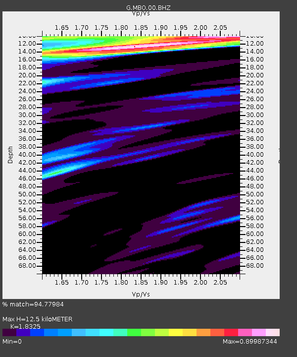
| Estimated Moho Depth: |
12.5 km |
| Estimated Crust Vp/Vs: |
1.83 |
| Assumed Crust Vp: |
5.55 km/s |
| Estimated Crust Vs: |
3.029 km/s |
| Estimated Crust Poisson's Ratio: |
0.29 |
|
| Radial Match: |
94.77984 % |
| Radial Bump: |
395 |
| Transverse Match: |
87.772995 % |
| Transverse Bump: |
400 |
| SOD ConfigId: |
19053131 |
| Insert Time: |
2019-09-10 23:58:50.153 +0000 |
| GWidth: |
2.5 |
| Max Bumps: |
400 |
| Tol: |
0.001 |
|
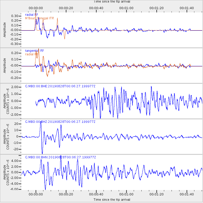
Signal To Noise
| Channel | StoN | STA | LTA |
| G:MBO:00:BHZ:20190828T00:06:27.199977Z | 21.213959 | 1.20612385E-5 | 5.6855197E-7 |
| G:MBO:00:BHN:20190828T00:06:27.199977Z | 3.9692879 | 1.7070673E-6 | 4.300689E-7 |
| G:MBO:00:BHE:20190828T00:06:27.199977Z | 1.0155379 | 3.5526543E-7 | 3.4982983E-7 |
| Arrivals |
| Ps | 1.9 SECOND |
| PpPs | 6.2 SECOND |
| PsPs/PpSs | 8.2 SECOND |


