You are here: Home > Network List > G - GEOSCOPE Stations List
> Station MPG Montagne des Peres, French Guyana > Earthquake Result Viewer
MPG Montagne des Peres, French Guyana - Earthquake Result Viewer
| Earthquake location: |
South Sandwich Islands Region |
| Earthquake latitude/longitude: |
-60.2/-26.5 |
| Earthquake time(UTC): |
2019/08/27 (239) 23:55:18 GMT |
| Earthquake Depth: |
10 km |
| Earthquake Magnitude: |
6.6 mww |
| Earthquake Catalog/Contributor: |
NEIC PDE/us |
|
| Network: |
G GEOSCOPE |
| Station: |
MPG Montagne des Peres, French Guyana |
| Lat/Lon: |
5.11 N/52.64 W |
| Elevation: |
147 m |
|
| Distance: |
68.3 deg |
| Az: |
331.844 deg |
| Baz: |
166.321 deg |
| Ray Param: |
0.056396093 |
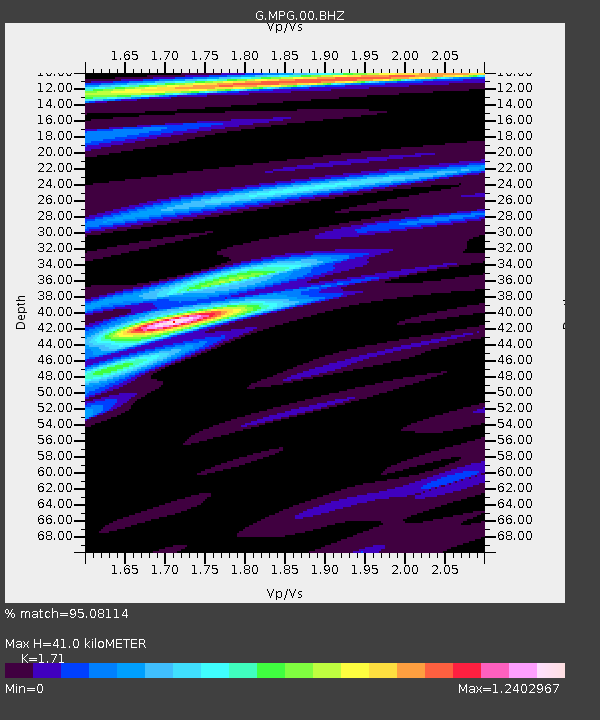
| Estimated Moho Depth: |
41.0 km |
| Estimated Crust Vp/Vs: |
1.71 |
| Assumed Crust Vp: |
6.472 km/s |
| Estimated Crust Vs: |
3.785 km/s |
| Estimated Crust Poisson's Ratio: |
0.24 |
|
| Radial Match: |
95.08114 % |
| Radial Bump: |
342 |
| Transverse Match: |
77.47417 % |
| Transverse Bump: |
400 |
| SOD ConfigId: |
19053131 |
| Insert Time: |
2019-09-10 23:58:51.037 +0000 |
| GWidth: |
2.5 |
| Max Bumps: |
400 |
| Tol: |
0.001 |
|
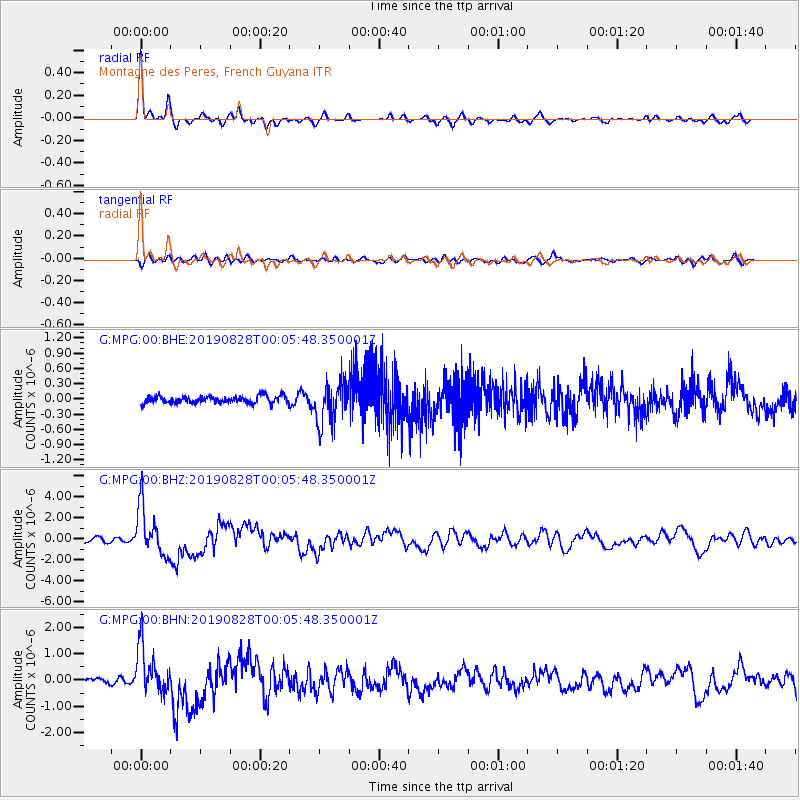
Signal To Noise
| Channel | StoN | STA | LTA |
| G:MPG:00:BHZ:20190828T00:05:48.350001Z | 13.80843 | 2.316018E-6 | 1.6772493E-7 |
| G:MPG:00:BHN:20190828T00:05:48.350001Z | 7.997534 | 9.152476E-7 | 1.1444123E-7 |
| G:MPG:00:BHE:20190828T00:05:48.350001Z | 5.7855177 | 4.0649954E-7 | 7.0261564E-8 |
| Arrivals |
| Ps | 4.7 SECOND |
| PpPs | 16 SECOND |
| PsPs/PpSs | 21 SECOND |


