You are here: Home > Network List > G - GEOSCOPE Stations List
> Station TAM Tamanrasset, Algeria > Earthquake Result Viewer
TAM Tamanrasset, Algeria - Earthquake Result Viewer
| Earthquake location: |
South Sandwich Islands Region |
| Earthquake latitude/longitude: |
-60.2/-26.5 |
| Earthquake time(UTC): |
2019/08/27 (239) 23:55:18 GMT |
| Earthquake Depth: |
10 km |
| Earthquake Magnitude: |
6.6 mww |
| Earthquake Catalog/Contributor: |
NEIC PDE/us |
|
| Network: |
G GEOSCOPE |
| Station: |
TAM Tamanrasset, Algeria |
| Lat/Lon: |
22.79 N/5.53 E |
| Elevation: |
1377 m |
|
| Distance: |
86.8 deg |
| Az: |
29.381 deg |
| Baz: |
195.389 deg |
| Ray Param: |
0.043823674 |
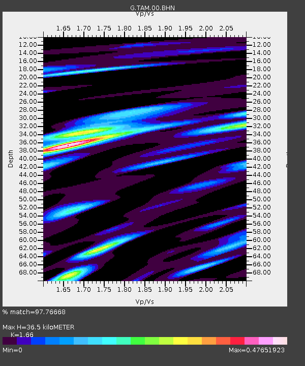
| Estimated Moho Depth: |
36.5 km |
| Estimated Crust Vp/Vs: |
1.66 |
| Assumed Crust Vp: |
6.61 km/s |
| Estimated Crust Vs: |
3.982 km/s |
| Estimated Crust Poisson's Ratio: |
0.22 |
|
| Radial Match: |
97.76668 % |
| Radial Bump: |
400 |
| Transverse Match: |
92.82398 % |
| Transverse Bump: |
400 |
| SOD ConfigId: |
19053131 |
| Insert Time: |
2019-09-10 23:58:53.224 +0000 |
| GWidth: |
2.5 |
| Max Bumps: |
400 |
| Tol: |
0.001 |
|
Signal To Noise
| Channel | StoN | STA | LTA |
| G:TAM:00:BHZ:20190828T00:07:31.100001Z | 37.036804 | 3.1677184E-6 | 8.552893E-8 |
| G:TAM:00:BHN:20190828T00:07:31.100001Z | 23.901756 | 8.495773E-7 | 3.5544556E-8 |
| G:TAM:00:BHE:20190828T00:07:31.100001Z | 7.067341 | 3.2199077E-7 | 4.5560384E-8 |
| Arrivals |
| Ps | 3.7 SECOND |
| PpPs | 14 SECOND |
| PsPs/PpSs | 18 SECOND |


